Koondoola geodata
Koondoola (Western Australia) is a section of populated place; located in Australia in Australia/Perth (GMT+8) time zone. With population of 3,969 people, there are 1799 cities with bigger population in this country. Compared to other cities in Australia, 67.7% of cities are located further ↓South; 94.3% of cities are located further →East and 66.1% of cities have lower elevation than Koondoola. Note1


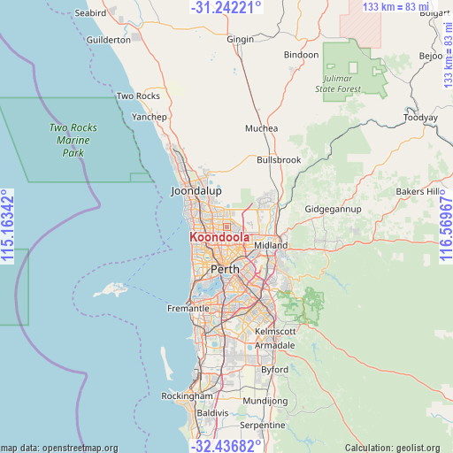
Koondoola GPS coordinates[2]
31° 50' 29.22" South, 115° 51' 59.544" East
| Map corner | latitude | longitude |
|---|---|---|
| Upper-left | -31.24221°, | 115.16342° |
| Center: | -31.84145°, | 115.86654° |
| Lower-right: | -32.43682°, | 116.56967° |
| Map W x H: | 132.8×132.8 km | = 82.5×82.5mi |
| max Lat: | -10.58257° ⇑32.3% North |
| Koondoola: | -31.84145° |
| min Lat: | ⇓67.7% South -43.31423° |
| min Long | Koondoola | max Long |
| 113.53327° | 115.86654° | 153.61246° |
| W 5.7%⇐ | ⇒94.3% E |
Elevation
Elevation of Koondoola is 84 m = 276 ft, and this is 38 m = 125 ft below average elevation for this country.
| Max E: |
1715 m = 5627 ft | 33.9% |
| Avg. | 122 m = 400 ft | |
| Koondoola | 84 m = 276 ft | |
Min E: |
-2 m = -7 ft | 66.1% |
See also: Australia elevation on elevation.city.
Geographical zone
Koondoola is located in South temperate zone (between Tropic of Capricorn and the Antarctic Circle). Distance of this Southern Tropic circle is 934.5 km =580.7 mi to North.| Distance of | km | miles | from Koondoola |
|---|---|---|---|
| Equator | 3540.4 | 2199.9 | to North |
| Tropic Capricorn | 934.5 | 580.7 | to North |
| Antarctic Circle | 3860.7 | 2398.9 | to South |
| South Pole | 6466.6 | 4018.2 | to South |


Nearby cities:
15 places around Koondoola: (largest is in red/bold)
• Alexander Heights
1.5 km =0.9 mi,  354°
354°
• Balcatta
5.2 km =3.2 mi,  223°
223°
• Balga
2.9 km =1.8 mi,  239°
239°
• Ballajura
2.7 km =1.7 mi,  88°
88°
• Darch
3.8 km =2.4 mi,  328°
328°
• Dianella
5.2 km =3.2 mi,  174°
174°
• Girrawheen
2.5 km =1.6 mi,  271°
271°
• Landsdale
3.8 km =2.4 mi,  359°
359°
• Madeley
5 km =3.1 mi,  312°
312°
• Marangaroo
3.1 km =1.9 mi,  300°
300°
• Mirrabooka
2 km =1.2 mi,  181°
181°
• Nollamara
4.7 km =2.9 mi,  204°
204°
• Noranda
4.7 km =2.9 mi,  139°
139°
• Warwick
5.5 km =3.4 mi, 271°
• Westminster
3.9 km =2.4 mi, 221°
Sources, notices
• [Note1] Compared only with cities in Australia existing in our database
• [Src1] Map data: © OpenStreetMap contributors (CC-BY-SA)
• [Src2] Other city data from geonames.org with taken over terms of usage.
• [Src3] Geographical zone / Annual Mean Temperature by Robert A. Rohde @ Wikipedia
