Girrawheen geodata
Girrawheen (Western Australia) is a section of populated place; located in Australia in Australia/Perth (GMT+8) time zone. With population of 8,672 people, there are 737 cities with bigger population in this country. Compared to other cities in Australia, 67.8% of cities are located further ↓South; 95% of cities are located further →East and 61.4% of cities have lower elevation than Girrawheen. Note1


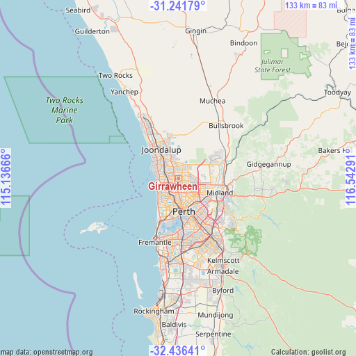
Girrawheen GPS coordinates[2]
31° 50' 27.708" South, 115° 50' 23.208" East
| Map corner | latitude | longitude |
|---|---|---|
| Upper-left | -31.24179°, | 115.13666° |
| Center: | -31.84103°, | 115.83978° |
| Lower-right: | -32.43641°, | 116.54291° |
| Map W x H: | 132.8×132.8 km | = 82.5×82.5mi |
| max Lat: | -10.58257° ⇑32.2% North |
| Girrawheen: | -31.84103° |
| min Lat: | ⇓67.8% South -43.31423° |
| min Long | Girrawheen | max Long |
| 113.53327° | 115.83978° | 153.61246° |
| W 5%⇐ | ⇒95% E |
Elevation
Elevation of Girrawheen is 68 m = 223 ft, and this is 54 m = 177 ft below average elevation for this country.
| Max E: |
1715 m = 5627 ft | 38.6% |
| Avg. | 122 m = 400 ft | |
| Girrawheen | 68 m = 223 ft | |
Min E: |
-2 m = -7 ft | 61.4% |
See also: Australia elevation on elevation.city.
Geographical zone
Girrawheen is located in South temperate zone (between Tropic of Capricorn and the Antarctic Circle). Distance of this Southern Tropic circle is 934.5 km =580.7 mi to North.| Distance of | km | miles | from Girrawheen |
|---|---|---|---|
| Equator | 3540.4 | 2199.9 | to North |
| Tropic Capricorn | 934.5 | 580.7 | to North |
| Antarctic Circle | 3860.8 | 2399 | to South |
| South Pole | 6466.7 | 4018.2 | to South |


Nearby cities:
15 places around Girrawheen: (largest is in red/bold)
• Alexander Heights
2.8 km =1.7 mi,  57°
57°
• Balcatta
3.9 km =2.4 mi,  195°
195°
• Balga
1.6 km =1 mi,  179°
179°
• Darch
3.2 km =2 mi,  10°
10°
• Greenwood
3.8 km =2.4 mi,  293°
293°
• Hamersley
3.2 km =2 mi,  253°
253°
• Kingsley
5 km =3.1 mi,  312°
312°
• Koondoola
2.5 km =1.6 mi,  91°
91°
• Landsdale
4.5 km =2.8 mi,  33°
33°
• Madeley
3.5 km =2.2 mi,  341°
341°
• Marangaroo
1.6 km =1 mi,  355°
355°
• Mirrabooka
3.2 km =2 mi,  130°
130°
• Nollamara
4.4 km =2.7 mi,  173°
173°
• Warwick
3 km =1.9 mi,  272°
272°
• Westminster
2.9 km =1.8 mi, 181°
Sources, notices
• [Note1] Compared only with cities in Australia existing in our database
• [Src1] Map data: © OpenStreetMap contributors (CC-BY-SA)
• [Src2] Other city data from geonames.org with taken over terms of usage.
• [Src3] Geographical zone / Annual Mean Temperature by Robert A. Rohde @ Wikipedia
