Tennyson geodata
Tennyson (South Australia) is a section of populated place; located in Australia in Australia/Adelaide (GMT+10.5) time zone. With population of 1,122 people, there are 3671 cities with bigger population in this country. Compared to other cities in Australia, 67.7% of cities are located further ↑North; 84.8% of cities are located further →East and 88.3% of cities have higher elevation than Tennyson. Note1


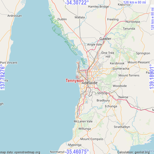
Tennyson GPS coordinates[2]
34° 53' 9.636" South, 138° 29' 9.168" East
| Map corner | latitude | longitude |
|---|---|---|
| Upper-left | -34.30722°, | 137.78276° |
| Center: | -34.88601°, | 138.48588° |
| Lower-right: | -35.46075°, | 139.18901° |
| Map W x H: | 128.3×128.3 km | = 79.7×79.7mi |
| max Lat: | -10.58257° ⇑67.7% North |
| Tennyson: | -34.88601° |
| min Lat: | ⇓32.3% South -43.31423° |
| min Long | Tennyson | max Long |
| 113.53327° | 138.48588° | 153.61246° |
| W 15.2%⇐ | ⇒84.8% E |
Elevation
Elevation of Tennyson is 10 m = 33 ft, and this is 112 m = 367 ft below average elevation for this country.
| Max E: |
1715 m = 5627 ft | 88.3% |
| Avg. | 122 m = 400 ft | |
| Tennyson | 10 m = 33 ft | |
Min E: |
-2 m = -7 ft | 11.7% |
See also: Australia elevation on elevation.city.
Geographical zone
Tennyson is located in South temperate zone (between Tropic of Capricorn and the Antarctic Circle). Distance of this Southern Tropic circle is 1273 km =791 mi to North.| Distance of | km | miles | from Tennyson |
|---|---|---|---|
| Equator | 3879 | 2410.3 | to North |
| Tropic Capricorn | 1273 | 791 | to North |
| Antarctic Circle | 3522.2 | 2188.6 | to South |
| South Pole | 6128.1 | 3807.8 | to South |


Nearby cities:
15 places around Tennyson: (largest is in red/bold)
• Albert Park
3.5 km =2.2 mi,  63°
63°
• Alberton
4.4 km =2.7 mi,  47°
47°
• Cheltenham
4 km =2.5 mi, 59°
• Ethelton
4.2 km =2.6 mi,  6°
6°
• Fulham Gardens
4.1 km =2.5 mi,  142°
142°
• Grange
1.8 km =1.1 mi,  167°
167°
• Henley Beach
3.9 km =2.4 mi, 168°
• Queenstown
3.6 km =2.2 mi,  38°
38°
• Royal Park
2.7 km =1.7 mi, 60°
• Seaton
3.2 km =2 mi,  118°
118°
• Semaphore Park
4 km =2.5 mi,  350°
350°
• Semaphore South
4.1 km =2.5 mi, 351°
• West Lakes
1.7 km =1.1 mi,  28°
28°
• West Lakes Shore
2.9 km =1.8 mi, 6°
• Woodville West
4.1 km =2.5 mi,  90°
90°
Sources, notices
• [Note1] Compared only with cities in Australia existing in our database
• [Src1] Map data: © OpenStreetMap contributors (CC-BY-SA)
• [Src2] Other city data from geonames.org with taken over terms of usage.
• [Src3] Geographical zone / Annual Mean Temperature by Robert A. Rohde @ Wikipedia
