Windradyne geodata
Windradyne (New South Wales) is a section of populated place; located in Australia in Australia/Sydney (GMT+11) time zone. With population of 2,868 people, there are 2335 cities with bigger population in this country. Compared to other cities in Australia, 54.5% of cities are located further ↓South; 56.2% of cities are located further ←West and 98.5% of cities have lower elevation than Windradyne. Note1


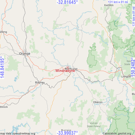
Windradyne GPS coordinates[2]
33° 24' 19.404" South, 149° 32' 42.252" East
| Map corner | latitude | longitude |
|---|---|---|
| Upper-left | -32.81645°, | 148.84195° |
| Center: | -33.40539°, | 149.54507° |
| Lower-right: | -33.99037°, | 150.2482° |
| Map W x H: | 130.5×130.5 km | = 81.1×81.1mi |
| max Lat: | -10.58257° ⇑45.5% North |
| Windradyne: | -33.40539° |
| min Lat: | ⇓54.5% South -43.31423° |
| min Long | Windradyne | max Long |
| 113.53327° | 149.54507° | 153.61246° |
| W 56.2%⇐ | ⇒43.8% E |
Elevation
Elevation of Windradyne is 708 m = 2323 ft, and this is 586 m = 1923 ft above average elevation for this country.
| Max E: |
1715 m = 5627 ft | 1.5% |
| Windradyne | 708 m 2323 ft | |
| Avg. | 122 m = 400 ft | |
Min E: |
-2 m = -7 ft | 98.5% |
See also: Australia elevation on elevation.city.
Geographical zone
Windradyne is located in South temperate zone (between Tropic of Capricorn and the Antarctic Circle). Distance of this Southern Tropic circle is 1108.4 km =688.7 mi to North.| Distance of | km | miles | from Windradyne |
|---|---|---|---|
| Equator | 3714.3 | 2308 | to North |
| Tropic Capricorn | 1108.4 | 688.7 | to North |
| Antarctic Circle | 3686.8 | 2290.9 | to South |
| South Pole | 6292.7 | 3910.1 | to South |


Nearby cities:
15 places around Windradyne: (largest is in red/bold)
• Abercrombie
1.9 km =1.2 mi,  2°
2°
• Bathurst
3.5 km =2.2 mi,  110°
110°
• Bathurst city centre
3.2 km =2 mi,  116°
116°
• Blayney
30.5 km =19 mi,  242°
242°
• Eglinton
3.1 km =1.9 mi, 2°
• Gormans Hill
8.3 km =5.2 mi,  145°
145°
• Kelso
5.3 km =3.3 mi,  103°
103°
• Llanarth
1.1 km =0.7 mi,  30°
30°
• Millthorpe
33.7 km =20.9 mi,  262°
262°
• Mitchell
2.7 km =1.7 mi,  156°
156°
• Perthville
9.1 km =5.7 mi,  179°
179°
• Raglan
11.4 km =7.1 mi, 96°
• Robin Hill
2.3 km =1.4 mi,  210°
210°
• South Bathurst
4.4 km =2.7 mi, 145°
• West Bathurst
1.7 km =1.1 mi, 104°
Sources, notices
• [Note1] Compared only with cities in Australia existing in our database
• [Src1] Map data: © OpenStreetMap contributors (CC-BY-SA)
• [Src2] Other city data from geonames.org with taken over terms of usage.
• [Src3] Geographical zone / Annual Mean Temperature by Robert A. Rohde @ Wikipedia
