Abercrombie geodata
Abercrombie (New South Wales) is a section of populated place; located in Australia in Australia/Sydney (GMT+11) time zone. With population of 1,095 people, there are 3703 cities with bigger population in this country. Compared to other cities in Australia, 54.6% of cities are located further ↓South; 56.2% of cities are located further ←West and 97.9% of cities have lower elevation than Abercrombie. Note1


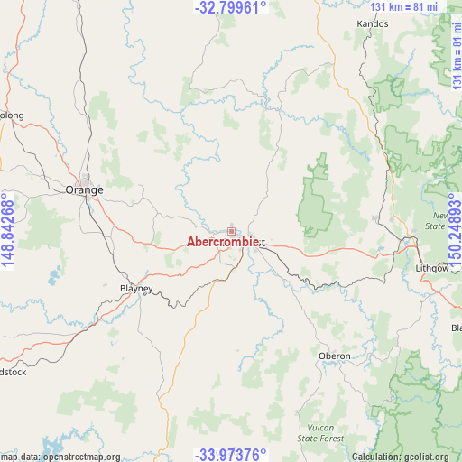
Abercrombie GPS coordinates[2]
33° 23' 19.212" South, 149° 32' 44.88" East
| Map corner | latitude | longitude |
|---|---|---|
| Upper-left | -32.79961°, | 148.84268° |
| Center: | -33.38867°, | 149.5458° |
| Lower-right: | -33.97376°, | 150.24893° |
| Map W x H: | 130.6×130.6 km | = 81.2×81.2mi |
| max Lat: | -10.58257° ⇑45.4% North |
| Abercrombie: | -33.38867° |
| min Lat: | ⇓54.6% South -43.31423° |
| min Long | Abercrombie | max Long |
| 113.53327° | 149.5458° | 153.61246° |
| W 56.2%⇐ | ⇒43.8% E |
Elevation
Elevation of Abercrombie is 669 m = 2195 ft, and this is 547 m = 1795 ft above average elevation for this country.
| Max E: |
1715 m = 5627 ft | 2.1% |
| Abercrombie | 669 m 2195 ft | |
| Avg. | 122 m = 400 ft | |
Min E: |
-2 m = -7 ft | 97.9% |
See also: Australia elevation on elevation.city.
Geographical zone
Abercrombie is located in South temperate zone (between Tropic of Capricorn and the Antarctic Circle). Distance of this Southern Tropic circle is 1106.6 km =687.6 mi to North.| Distance of | km | miles | from Abercrombie |
|---|---|---|---|
| Equator | 3712.5 | 2306.8 | to North |
| Tropic Capricorn | 1106.6 | 687.6 | to North |
| Antarctic Circle | 3688.7 | 2292.1 | to South |
| South Pole | 6294.6 | 3911.3 | to South |


Nearby cities:
15 places around Abercrombie: (largest is in red/bold)
• Bathurst
4.5 km =2.8 mi,  133°
133°
• Bathurst city centre
4.3 km =2.7 mi,  139°
139°
• Blayney
31.5 km =19.6 mi,  239°
239°
• Eglinton
1.3 km =0.8 mi,  3°
3°
• Gormans Hill
9.9 km =6.2 mi,  152°
152°
• Kelso
5.9 km =3.7 mi,  121°
121°
• Llanarth
1 km =0.6 mi, 151°
• Millthorpe
34.1 km =21.2 mi,  259°
259°
• Mitchell
4.4 km =2.7 mi,  166°
166°
• Perthville
11 km =6.8 mi,  179°
179°
• Raglan
11.6 km =7.2 mi,  105°
105°
• Robin Hill
4 km =2.5 mi,  197°
197°
• South Bathurst
6 km =3.7 mi,  156°
156°
• West Bathurst
2.8 km =1.7 mi, 144°
• Windradyne
1.9 km =1.2 mi, 182°
Sources, notices
• [Note1] Compared only with cities in Australia existing in our database
• [Src1] Map data: © OpenStreetMap contributors (CC-BY-SA)
• [Src2] Other city data from geonames.org with taken over terms of usage.
• [Src3] Geographical zone / Annual Mean Temperature by Robert A. Rohde @ Wikipedia
