Raglan geodata
Raglan (New South Wales) is a populated place; located in Australia in Australia/Sydney (GMT+11) time zone. With population of 1,175 people, there are 3614 cities with bigger population in this country. Compared to other cities in Australia, 54.3% of cities are located further ↓South; 56.5% of cities are located further ←West and 98.8% of cities have lower elevation than Raglan. Note1


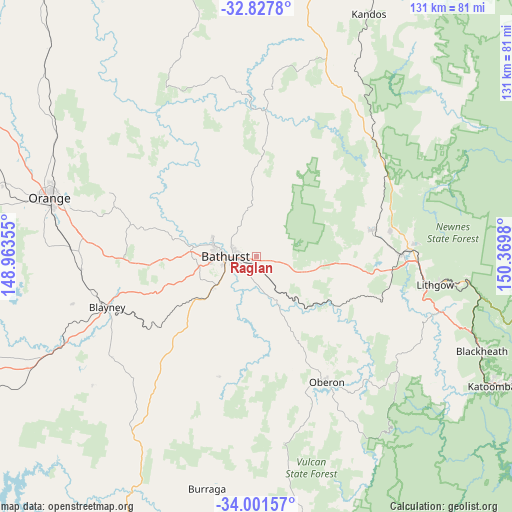
Raglan GPS coordinates[2]
33° 25' 0.012" South, 149° 40' 0.012" East
| Map corner | latitude | longitude |
|---|---|---|
| Upper-left | -32.8278°, | 148.96355° |
| Center: | -33.41667°, | 149.66667° |
| Lower-right: | -34.00157°, | 150.3698° |
| Map W x H: | 130.5×130.5 km | = 81.1×81.1mi |
| max Lat: | -10.58257° ⇑45.7% North |
| Raglan: | -33.41667° |
| min Lat: | ⇓54.3% South -43.31423° |
| min Long | Raglan | max Long |
| 113.53327° | 149.66667° | 153.61246° |
| W 56.5%⇐ | ⇒43.5% E |
Elevation
Elevation of Raglan is 764 m = 2507 ft, and this is 642 m = 2106 ft above average elevation for this country.
| Max E: |
1715 m = 5627 ft | 1.2% |
| Raglan | 764 m 2507 ft | |
| Avg. | 122 m = 400 ft | |
Min E: |
-2 m = -7 ft | 98.8% |
See also: Australia elevation on elevation.city.
Geographical zone
Raglan is located in South temperate zone (between Tropic of Capricorn and the Antarctic Circle). Distance of this Southern Tropic circle is 1109.7 km =689.5 mi to North.| Distance of | km | miles | from Raglan |
|---|---|---|---|
| Equator | 3715.6 | 2308.8 | to North |
| Tropic Capricorn | 1109.7 | 689.5 | to North |
| Antarctic Circle | 3685.6 | 2290.1 | to South |
| South Pole | 6291.5 | 3909.4 | to South |


Nearby cities:
15 places around Raglan: (largest is in red/bold)
• Abercrombie
11.6 km =7.2 mi,  285°
285°
• Bathurst
8 km =5 mi,  270°
270°
• Bathurst city centre
8.4 km =5.2 mi, 268°
• Eglinton
12 km =7.5 mi, 291°
• Gormans Hill
8.7 km =5.4 mi,  229°
229°
• Kelso
6.2 km =3.9 mi, 270°
• Llanarth
11 km =6.8 mi,  281°
281°
• Mitchell
10.3 km =6.4 mi,  263°
263°
• Oberon
36.6 km =22.7 mi,  150°
150°
• Perthville
13.6 km =8.5 mi, 234°
• Portland
30 km =18.6 mi,  77°
77°
• Robin Hill
12.4 km =7.7 mi, 266°
• South Bathurst
9.1 km =5.7 mi,  254°
254°
• West Bathurst
9.6 km =6 mi, 274°
• Windradyne
11.4 km =7.1 mi, 276°
Sources, notices
• [Note1] Compared only with cities in Australia existing in our database
• [Src1] Map data: © OpenStreetMap contributors (CC-BY-SA)
• [Src2] Other city data from geonames.org with taken over terms of usage.
• [Src3] Geographical zone / Annual Mean Temperature by Robert A. Rohde @ Wikipedia
