Kialla geodata
Kialla (Victoria) is a section of populated place; located in Australia in Australia/Melbourne (GMT+11) time zone. With population of 6,608 people, there are 1048 cities with bigger population in this country. Compared to other cities in Australia, 79.9% of cities are located further ↑North; 60.3% of cities are located further →East and 72.9% of cities have lower elevation than Kialla. Note1


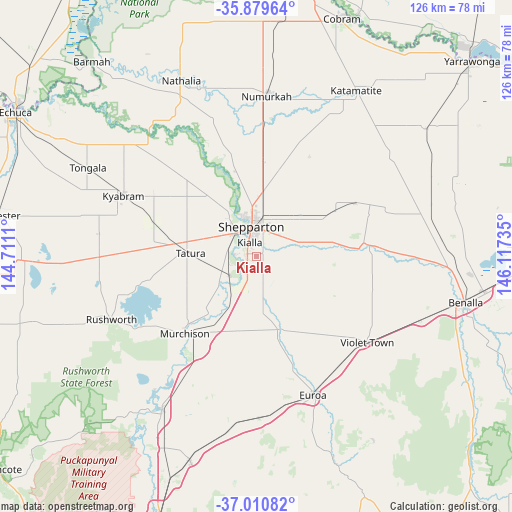
Kialla GPS coordinates[2]
36° 26' 50.244" South, 145° 24' 51.192" East
| Map corner | latitude | longitude |
|---|---|---|
| Upper-left | -35.87964°, | 144.7111° |
| Center: | -36.44729°, | 145.41422° |
| Lower-right: | -37.01082°, | 146.11735° |
| Map W x H: | 125.8×125.8 km | = 78.2×78.2mi |
| max Lat: | -10.58257° ⇑79.9% North |
| Kialla: | -36.44729° |
| min Lat: | ⇓20.1% South -43.31423° |
| min Long | Kialla | max Long |
| 113.53327° | 145.41422° | 153.61246° |
| W 39.7%⇐ | ⇒60.3% E |
Elevation
Elevation of Kialla is 117 m = 384 ft, and this is 5 m = 16 ft below average elevation for this country.
| Max E: |
1715 m = 5627 ft | 27.1% |
| Avg. | 122 m = 400 ft | |
| Kialla | 117 m = 384 ft | |
Min E: |
-2 m = -7 ft | 72.9% |
See also: Australia elevation on elevation.city.
Geographical zone
Kialla is located in South temperate zone (between Tropic of Capricorn and the Antarctic Circle). Distance of this Southern Tropic circle is 1446.6 km =898.9 mi to North.| Distance of | km | miles | from Kialla |
|---|---|---|---|
| Equator | 4052.6 | 2518.2 | to North |
| Tropic Capricorn | 1446.6 | 898.9 | to North |
| Antarctic Circle | 3348.6 | 2080.7 | to South |
| South Pole | 5954.5 | 3700 | to South |


Nearby cities:
15 places around Kialla: (largest is in red/bold)
• Congupna
16.5 km =10.3 mi,  5°
5°
• Euroa
37 km =23 mi,  157°
157°
• Grahamvale
11.2 km =7 mi, 10°
• Invergordon
34.7 km =21.6 mi,  25°
25°
• Kyabram
35.8 km =22.2 mi,  294°
294°
• Merrigum
26.6 km =16.5 mi, 288°
• Mooroopna
7.8 km =4.8 mi,  312°
312°
• Murchison
26 km =16.2 mi,  222°
222°
• Shepparton
7.6 km =4.7 mi,  349°
349°
• Shepparton East
7.6 km =4.7 mi,  48°
48°
• Stanhope
38.6 km =24 mi,  270°
270°
• Tallygaroopna
22 km =13.7 mi,  4°
4°
• Tatura
16.5 km =10.3 mi, 272°
• Toolamba
8.2 km =5.1 mi, 224°
• Violet Town
34.1 km =21.2 mi,  127°
127°
Sources, notices
• [Note1] Compared only with cities in Australia existing in our database
• [Src1] Map data: © OpenStreetMap contributors (CC-BY-SA)
• [Src2] Other city data from geonames.org with taken over terms of usage.
• [Src3] Geographical zone / Annual Mean Temperature by Robert A. Rohde @ Wikipedia
