Tallygaroopna geodata
Tallygaroopna (Victoria) is a populated place; located in Australia in Australia/Melbourne (GMT+11) time zone. With population of 561 people, there are 4678 cities with bigger population in this country. Compared to other cities in Australia, 79.2% of cities are located further ↑North; 60.2% of cities are located further →East and 70.7% of cities have lower elevation than Tallygaroopna. Note1


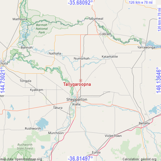
Tallygaroopna GPS coordinates[2]
36° 15' 0" South, 145° 25' 59.988" East
| Map corner | latitude | longitude |
|---|---|---|
| Upper-left | -35.68092°, | 144.73021° |
| Center: | -36.25°, | 145.43333° |
| Lower-right: | -36.81497°, | 146.13646° |
| Map W x H: | 126.1×126.1 km | = 78.4×78.4mi |
| max Lat: | -10.58257° ⇑79.2% North |
| Tallygaroopna: | -36.25° |
| min Lat: | ⇓20.8% South -43.31423° |
| min Long | Tallygaroopna | max Long |
| 113.53327° | 145.43333° | 153.61246° |
| W 39.8%⇐ | ⇒60.2% E |
Elevation
Elevation of Tallygaroopna is 107 m = 351 ft, and this is 15 m = 49 ft below average elevation for this country.
| Max E: |
1715 m = 5627 ft | 29.3% |
| Avg. | 122 m = 400 ft | |
| Tallygaroopna | 107 m = 351 ft | |
Min E: |
-2 m = -7 ft | 70.7% |
See also: Australia elevation on elevation.city.
Geographical zone
Tallygaroopna is located in South temperate zone (between Tropic of Capricorn and the Antarctic Circle). Distance of this Southern Tropic circle is 1424.7 km =885.3 mi to North.| Distance of | km | miles | from Tallygaroopna |
|---|---|---|---|
| Equator | 4030.6 | 2504.5 | to North |
| Tropic Capricorn | 1424.7 | 885.3 | to North |
| Antarctic Circle | 3370.6 | 2094.4 | to South |
| South Pole | 5976.4 | 3713.6 | to South |


Nearby cities:
15 places around Tallygaroopna: (largest is in red/bold)
• Congupna
5.6 km =3.5 mi,  180°
180°
• Grahamvale
10.9 km =6.8 mi, 178°
• Invergordon
16.3 km =10.1 mi,  55°
55°
• Katunga
26.5 km =16.5 mi,  7°
7°
• Kialla
22 km =13.7 mi, 184°
• Kyabram
35 km =21.7 mi,  258°
258°
• Merrigum
30.2 km =18.8 mi,  243°
243°
• Mooroopna
18.3 km =11.4 mi,  204°
204°
• Nathalia
29.7 km =18.5 mi,  316°
316°
• Numurkah
18 km =11.2 mi,  2°
2°
• Shepparton
14.8 km =9.2 mi,  192°
192°
• Shepparton East
17.3 km =10.7 mi,  166°
166°
• Strathmerton
36.3 km =22.6 mi, 6°
• Tatura
27.9 km =17.3 mi,  220°
220°
• Toolamba
28.8 km =17.9 mi, 195°
Sources, notices
• [Note1] Compared only with cities in Australia existing in our database
• [Src1] Map data: © OpenStreetMap contributors (CC-BY-SA)
• [Src2] Other city data from geonames.org with taken over terms of usage.
• [Src3] Geographical zone / Annual Mean Temperature by Robert A. Rohde @ Wikipedia
