Violet Town geodata
Violet Town (Victoria) is a populated place; located in Australia in Australia/Melbourne (GMT+11) time zone. With population of 829 people, there are 4099 cities with bigger population in this country. Compared to other cities in Australia, 80.3% of cities are located further ↑North; 58.5% of cities are located further →East and 79.8% of cities have lower elevation than Violet Town. Note1


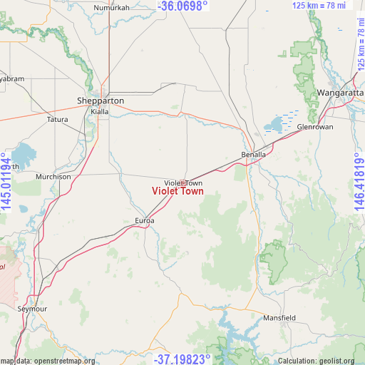
Violet Town GPS coordinates[2]
36° 38' 9.888" South, 145° 42' 54.216" East
| Map corner | latitude | longitude |
|---|---|---|
| Upper-left | -36.0698°, | 145.01194° |
| Center: | -36.63608°, | 145.71506° |
| Lower-right: | -37.19823°, | 146.41819° |
| Map W x H: | 125.5×125.5 km | = 78×78mi |
| max Lat: | -10.58257° ⇑80.3% North |
| Violet Town: | -36.63608° |
| min Lat: | ⇓19.7% South -43.31423° |
| min Long | Violet Town | max Long |
| 113.53327° | 145.71506° | 153.61246° |
| W 41.5%⇐ | ⇒58.5% E |
Elevation
Elevation of Violet Town is 179 m = 587 ft, and this is 57 m = 187 ft above average elevation for this country.
| Max E: |
1715 m = 5627 ft | 20.2% |
| Violet Town | 179 m 587 ft | |
| Avg. | 122 m = 400 ft | |
Min E: |
-2 m = -7 ft | 79.8% |
See also: Australia elevation on elevation.city.
Geographical zone
Violet Town is located in South temperate zone (between Tropic of Capricorn and the Antarctic Circle). Distance of this Southern Tropic circle is 1467.6 km =911.9 mi to North.| Distance of | km | miles | from Violet Town |
|---|---|---|---|
| Equator | 4073.6 | 2531.2 | to North |
| Tropic Capricorn | 1467.6 | 911.9 | to North |
| Antarctic Circle | 3327.6 | 2067.7 | to South |
| South Pole | 5933.5 | 3686.9 | to South |


Nearby cities:
15 places around Violet Town: (largest is in red/bold)
• Avenel
52 km =32.3 mi,  235°
235°
• Benalla
25.8 km =16 mi,  68°
68°
• Bonnie Doon
44.4 km =27.6 mi,  162°
162°
• Congupna
45.1 km =28 mi,  326°
326°
• Euroa
18.5 km =11.5 mi,  224°
224°
• Glenrowan
49.4 km =30.7 mi, 67°
• Grahamvale
40.6 km =25.2 mi,  322°
322°
• Kialla
34.1 km =21.2 mi,  307°
307°
• Mooroopna
41.9 km =26 mi, 308°
• Murchison
44.5 km =27.7 mi,  272°
272°
• Shepparton
40.1 km =24.9 mi, 315°
• Shepparton East
33.6 km =20.9 mi, 320°
• Tallygaroopna
49.8 km =30.9 mi, 329°
• Tatura
48.5 km =30.1 mi,  296°
296°
• Toolamba
35.9 km =22.3 mi,  294°
294°
Sources, notices
• [Note1] Compared only with cities in Australia existing in our database
• [Src1] Map data: © OpenStreetMap contributors (CC-BY-SA)
• [Src2] Other city data from geonames.org with taken over terms of usage.
• [Src3] Geographical zone / Annual Mean Temperature by Robert A. Rohde @ Wikipedia
