Shepparton East geodata
Shepparton East (Victoria) is a section of populated place; located in Australia in Australia/Melbourne (GMT+11) time zone. With population of 1,100 people, there are 3694 cities with bigger population in this country. Compared to other cities in Australia, 79.8% of cities are located further ↑North; 59.8% of cities are located further →East and 73.2% of cities have lower elevation than Shepparton East. Note1


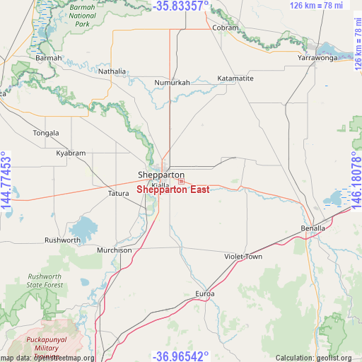
Shepparton East GPS coordinates[2]
36° 24' 5.616" South, 145° 28' 39.54" East
| Map corner | latitude | longitude |
|---|---|---|
| Upper-left | -35.83357°, | 144.77453° |
| Center: | -36.40156°, | 145.47765° |
| Lower-right: | -36.96542°, | 146.18078° |
| Map W x H: | 125.8×125.8 km | = 78.2×78.2mi |
| max Lat: | -10.58257° ⇑79.8% North |
| Shepparton East: | -36.40156° |
| min Lat: | ⇓20.2% South -43.31423° |
| min Long | Shepparton East | max Long |
| 113.53327° | 145.47765° | 153.61246° |
| W 40.2%⇐ | ⇒59.8% E |
Elevation
Elevation of Shepparton East is 118 m = 387 ft, and this is 4 m = 13 ft below average elevation for this country.
| Max E: |
1715 m = 5627 ft | 26.8% |
| Avg. | 122 m = 400 ft | |
| Shepparton East | 118 m = 387 ft | |
Min E: |
-2 m = -7 ft | 73.2% |
See also: Australia elevation on elevation.city.
Geographical zone
Shepparton East is located in South temperate zone (between Tropic of Capricorn and the Antarctic Circle). Distance of this Southern Tropic circle is 1441.6 km =895.8 mi to North.| Distance of | km | miles | from Shepparton East |
|---|---|---|---|
| Equator | 4047.5 | 2515 | to North |
| Tropic Capricorn | 1441.6 | 895.8 | to North |
| Antarctic Circle | 3353.7 | 2083.9 | to South |
| South Pole | 5959.6 | 3703.1 | to South |


Nearby cities:
15 places around Shepparton East: (largest is in red/bold)
• Congupna
12 km =7.5 mi,  340°
340°
• Euroa
40.2 km =25 mi,  168°
168°
• Grahamvale
7 km =4.3 mi,  327°
327°
• Invergordon
27.8 km =17.3 mi,  19°
19°
• Kialla
7.6 km =4.7 mi,  228°
228°
• Kyabram
39.5 km =24.5 mi,  284°
284°
• Merrigum
31.1 km =19.3 mi, 275°
• Mooroopna
11.4 km =7.1 mi,  270°
270°
• Murchison
33.6 km =20.9 mi,  223°
223°
• Numurkah
35 km =21.7 mi,  354°
354°
• Shepparton
7.4 km =4.6 mi,  288°
288°
• Tallygaroopna
17.3 km =10.7 mi, 346°
• Tatura
22.6 km =14 mi,  259°
259°
• Toolamba
15.8 km =9.8 mi, 226°
• Violet Town
33.6 km =20.9 mi,  140°
140°
Sources, notices
• [Note1] Compared only with cities in Australia existing in our database
• [Src1] Map data: © OpenStreetMap contributors (CC-BY-SA)
• [Src2] Other city data from geonames.org with taken over terms of usage.
• [Src3] Geographical zone / Annual Mean Temperature by Robert A. Rohde @ Wikipedia
