Plumpton geodata
Plumpton (Victoria) is a section of populated place; located in Australia in Australia/Melbourne (GMT+11) time zone. With population of 4,320 people, there are 1674 cities with bigger population in this country. Compared to other cities in Australia, 84.5% of cities are located further ↑North; 69.6% of cities are located further →East and 76% of cities have lower elevation than Plumpton. Note1


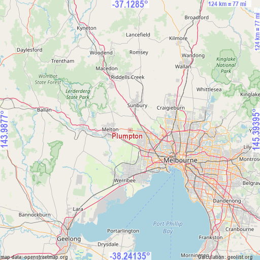
Plumpton GPS coordinates[2]
37° 41' 13.236" South, 144° 41' 26.952" East
| Map corner | latitude | longitude |
|---|---|---|
| Upper-left | -37.1285°, | 143.9877° |
| Center: | -37.68701°, | 144.69082° |
| Lower-right: | -38.24135°, | 145.39395° |
| Map W x H: | 123.7×123.7 km | = 76.9×76.9mi |
| max Lat: | -10.58257° ⇑84.5% North |
| Plumpton: | -37.68701° |
| min Lat: | ⇓15.5% South -43.31423° |
| min Long | Plumpton | max Long |
| 113.53327° | 144.69082° | 153.61246° |
| W 30.4%⇐ | ⇒69.6% E |
Elevation
Elevation of Plumpton is 139 m = 456 ft, and this is 17 m = 56 ft above average elevation for this country.
| Max E: |
1715 m = 5627 ft | 24% |
| Plumpton | 139 m 456 ft | |
| Avg. | 122 m = 400 ft | |
Min E: |
-2 m = -7 ft | 76% |
See also: Australia elevation on elevation.city.
Geographical zone
Plumpton is located in South temperate zone (between Tropic of Capricorn and the Antarctic Circle). Distance of this Southern Tropic circle is 1584.5 km =984.6 mi to North.| Distance of | km | miles | from Plumpton |
|---|---|---|---|
| Equator | 4190.4 | 2603.8 | to North |
| Tropic Capricorn | 1584.5 | 984.6 | to North |
| Antarctic Circle | 3210.8 | 1995.1 | to South |
| South Pole | 5816.7 | 3614.3 | to South |


Nearby cities:
15 places around Plumpton: (largest is in red/bold)
• Albanvale
9.5 km =5.9 mi,  133°
133°
• Burnside
8.8 km =5.5 mi,  141°
141°
• Burnside Heights
7 km =4.3 mi, 129°
• Caroline Springs
7.2 km =4.5 mi,  146°
146°
• Delahey
8.4 km =5.2 mi,  115°
115°
• Diggers Rest
7.2 km =4.5 mi,  19°
19°
• Hillside
4.5 km =2.8 mi,  94°
94°
• Keilor Lodge
10 km =6.2 mi,  98°
98°
• Kings Park
9.3 km =5.8 mi, 124°
• Kurunjang
8.4 km =5.2 mi,  278°
278°
• Melton
9.3 km =5.8 mi,  272°
272°
• Rockbank
5.5 km =3.4 mi,  199°
199°
• Sydenham
6.8 km =4.2 mi, 102°
• Taylors Hill
6.2 km =3.9 mi,  114°
114°
• Taylors Lakes
8.5 km =5.3 mi, 98°
Sources, notices
• [Note1] Compared only with cities in Australia existing in our database
• [Src1] Map data: © OpenStreetMap contributors (CC-BY-SA)
• [Src2] Other city data from geonames.org with taken over terms of usage.
• [Src3] Geographical zone / Annual Mean Temperature by Robert A. Rohde @ Wikipedia
