Melton geodata
Melton (Victoria) is a section of populated place; located in Australia in Australia/Melbourne (GMT+11) time zone. With population of 7,999 people, there are 834 cities with bigger population in this country. Compared to other cities in Australia, 84.4% of cities are located further ↑North; 69.9% of cities are located further →East and 76% of cities have lower elevation than Melton. Note1


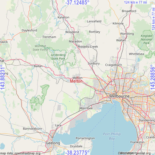
Melton GPS coordinates[2]
37° 41' 0.204" South, 144° 35' 7.548" East
| Map corner | latitude | longitude |
|---|---|---|
| Upper-left | -37.12485°, | 143.88231° |
| Center: | -37.68339°, | 144.58543° |
| Lower-right: | -38.23775°, | 145.28856° |
| Map W x H: | 123.7×123.7 km | = 76.9×76.9mi |
| max Lat: | -10.58257° ⇑84.4% North |
| Melton: | -37.68339° |
| min Lat: | ⇓15.6% South -43.31423° |
| min Long | Melton | max Long |
| 113.53327° | 144.58543° | 153.61246° |
| W 30.1%⇐ | ⇒69.9% E |
Elevation
Elevation of Melton is 138 m = 453 ft, and this is 16 m = 52 ft above average elevation for this country.
| Max E: |
1715 m = 5627 ft | 24% |
| Melton | 138 m 453 ft | |
| Avg. | 122 m = 400 ft | |
Min E: |
-2 m = -7 ft | 76% |
See also: Australia elevation on elevation.city.
Geographical zone
Melton is located in South temperate zone (between Tropic of Capricorn and the Antarctic Circle). Distance of this Southern Tropic circle is 1584.1 km =984.3 mi to North.| Distance of | km | miles | from Melton |
|---|---|---|---|
| Equator | 4190 | 2603.5 | to North |
| Tropic Capricorn | 1584.1 | 984.3 | to North |
| Antarctic Circle | 3211.2 | 1995.3 | to South |
| South Pole | 5817.1 | 3614.6 | to South |


Nearby cities:
15 places around Melton: (largest is in red/bold)
• Bacchus Marsh
13 km =8.1 mi,  275°
275°
• Brookfield
2.9 km =1.8 mi,  228°
228°
• Caroline Springs
14.7 km =9.1 mi,  115°
115°
• Darley
12.8 km =8 mi, 282°
• Diggers Rest
13.4 km =8.3 mi,  61°
61°
• Eynesbury
13 km =8.1 mi,  184°
184°
• Hillside
13.8 km =8.6 mi,  93°
93°
• Hopetoun Park
7.5 km =4.7 mi,  261°
261°
• Kurunjang
1.3 km =0.8 mi,  50°
50°
• Maddingley
13.5 km =8.4 mi,  269°
269°
• Melton South
2.9 km =1.8 mi,  198°
198°
• Melton West
1.6 km =1 mi,  290°
290°
• Plumpton
9.3 km =5.8 mi, 92°
• Rockbank
9.3 km =5.8 mi,  126°
126°
• Toolern Vale
9.4 km =5.8 mi,  7°
7°
Sources, notices
• [Note1] Compared only with cities in Australia existing in our database
• [Src1] Map data: © OpenStreetMap contributors (CC-BY-SA)
• [Src2] Other city data from geonames.org with taken over terms of usage.
• [Src3] Geographical zone / Annual Mean Temperature by Robert A. Rohde @ Wikipedia
