Casuarina geodata
Casuarina (Western Australia) is a section of populated place; located in Australia in Australia/Perth (GMT+8) time zone. With population of 1,724 people, there are 3093 cities with bigger population in this country. Compared to other cities in Australia, 62.6% of cities are located further ↓South; 94.3% of cities are located further →East and 67.2% of cities have higher elevation than Casuarina. Note1


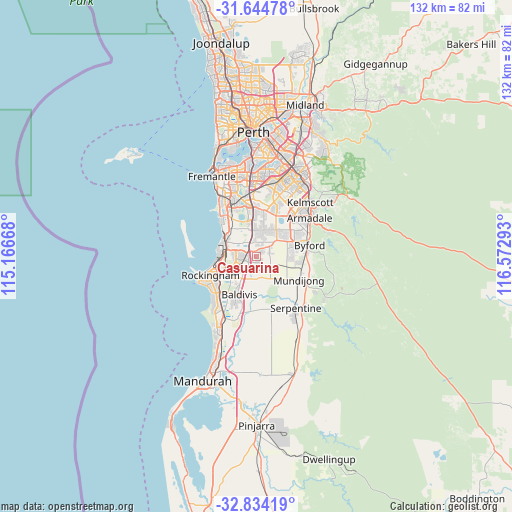
Casuarina GPS coordinates[2]
32° 14' 29.148" South, 115° 52' 11.28" East
| Map corner | latitude | longitude |
|---|---|---|
| Upper-left | -31.64478°, | 115.16668° |
| Center: | -32.24143°, | 115.8698° |
| Lower-right: | -32.83419°, | 116.57293° |
| Map W x H: | 132.2×132.2 km | = 82.1×82.1mi |
| max Lat: | -10.58257° ⇑37.4% North |
| Casuarina: | -32.24143° |
| min Lat: | ⇓62.6% South -43.31423° |
| min Long | Casuarina | max Long |
| 113.53327° | 115.8698° | 153.61246° |
| W 5.7%⇐ | ⇒94.3% E |
Elevation
Elevation of Casuarina is 25 m = 82 ft, and this is 97 m = 318 ft below average elevation for this country.
| Max E: |
1715 m = 5627 ft | 67.2% |
| Avg. | 122 m = 400 ft | |
| Casuarina | 25 m = 82 ft | |
Min E: |
-2 m = -7 ft | 32.8% |
See also: Australia elevation on elevation.city.
Geographical zone
Casuarina is located in South temperate zone (between Tropic of Capricorn and the Antarctic Circle). Distance of this Southern Tropic circle is 979 km =608.3 mi to North.| Distance of | km | miles | from Casuarina |
|---|---|---|---|
| Equator | 3584.9 | 2227.6 | to North |
| Tropic Capricorn | 979 | 608.3 | to North |
| Antarctic Circle | 3816.3 | 2371.3 | to South |
| South Pole | 6422.2 | 3990.6 | to South |


Nearby cities:
15 places around Casuarina: (largest is in red/bold)
• Atwell
10.9 km =6.8 mi,  357°
357°
• Aubin Grove
8.3 km =5.2 mi, 355°
• Baldivis
10.4 km =6.5 mi,  200°
200°
• Bertram
2.3 km =1.4 mi,  263°
263°
• Calista
6.8 km =4.2 mi,  270°
270°
• Cardup
11 km =6.8 mi,  99°
99°
• Hammond Park
8.3 km =5.2 mi,  347°
347°
• Kwinana
8.4 km =5.2 mi,  278°
278°
• Leda
7.2 km =4.5 mi,  246°
246°
• Medina
6.7 km =4.2 mi, 277°
• Oakford
7.5 km =4.7 mi,  53°
53°
• Orelia
4.6 km =2.9 mi, 281°
• Parmelia
4.8 km =3 mi, 247°
• Wandi
5.3 km =3.3 mi,  6°
6°
• Wellard
4.4 km =2.7 mi,  230°
230°
Sources, notices
• [Note1] Compared only with cities in Australia existing in our database
• [Src1] Map data: © OpenStreetMap contributors (CC-BY-SA)
• [Src2] Other city data from geonames.org with taken over terms of usage.
• [Src3] Geographical zone / Annual Mean Temperature by Robert A. Rohde @ Wikipedia
