Aubin Grove geodata
Aubin Grove (Western Australia) is a section of populated place; located in Australia in Australia/Perth (GMT+8) time zone. With population of 6,183 people, there are 1158 cities with bigger population in this country. Compared to other cities in Australia, 62.9% of cities are located further ↓South; 94.6% of cities are located further →East and 64.8% of cities have higher elevation than Aubin Grove. Note1


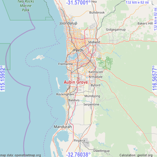
Aubin Grove GPS coordinates[2]
32° 10' 1.704" South, 115° 51' 45.504" East
| Map corner | latitude | longitude |
|---|---|---|
| Upper-left | -31.57001°, | 115.15952° |
| Center: | -32.16714°, | 115.86264° |
| Lower-right: | -32.76038°, | 116.56577° |
| Map W x H: | 132.4×132.4 km | = 82.3×82.3mi |
| max Lat: | -10.58257° ⇑37.1% North |
| Aubin Grove: | -32.16714° |
| min Lat: | ⇓62.9% South -43.31423° |
| min Long | Aubin Grove | max Long |
| 113.53327° | 115.86264° | 153.61246° |
| W 5.4%⇐ | ⇒94.6% E |
Elevation
Elevation of Aubin Grove is 27 m = 89 ft, and this is 95 m = 312 ft below average elevation for this country.
| Max E: |
1715 m = 5627 ft | 64.8% |
| Avg. | 122 m = 400 ft | |
| Aubin Grove | 27 m = 89 ft | |
Min E: |
-2 m = -7 ft | 35.2% |
See also: Australia elevation on elevation.city.
Geographical zone
Aubin Grove is located in South temperate zone (between Tropic of Capricorn and the Antarctic Circle). Distance of this Southern Tropic circle is 970.7 km =603.2 mi to North.| Distance of | km | miles | from Aubin Grove |
|---|---|---|---|
| Equator | 3576.7 | 2222.5 | to North |
| Tropic Capricorn | 970.7 | 603.2 | to North |
| Antarctic Circle | 3824.5 | 2376.4 | to South |
| South Pole | 6430.4 | 3995.7 | to South |


Nearby cities:
15 places around Aubin Grove: (largest is in red/bold)
• Atwell
2.6 km =1.6 mi,  5°
5°
• Banjup
3.6 km =2.2 mi,  38°
38°
• Beeliar
6.5 km =4 mi,  305°
305°
• City of Cockburn
7.4 km =4.6 mi,  346°
346°
• Cockburn Central
5.3 km =3.3 mi,  344°
344°
• Forrestdale
6.9 km =4.3 mi,  78°
78°
• Hammond Park
1.2 km =0.7 mi,  262°
262°
• Jandakot
7.3 km =4.5 mi, 6°
• Munster
8.2 km =5.1 mi,  294°
294°
• Oakford
7.7 km =4.8 mi,  119°
119°
• Piara Waters
6.3 km =3.9 mi,  53°
53°
• South Lake
6.6 km =4.1 mi, 340°
• Success
3 km =1.9 mi, 336°
• Wandi
3.3 km =2.1 mi,  156°
156°
• Yangebup
6.8 km =4.2 mi,  319°
319°
Sources, notices
• [Note1] Compared only with cities in Australia existing in our database
• [Src1] Map data: © OpenStreetMap contributors (CC-BY-SA)
• [Src2] Other city data from geonames.org with taken over terms of usage.
• [Src3] Geographical zone / Annual Mean Temperature by Robert A. Rohde @ Wikipedia
