Sheldon geodata
Sheldon (Queensland) is a section of populated place; located in Australia in Australia/Brisbane (GMT+10) time zone. With population of 1,667 people, there are 3124 cities with bigger population in this country. Compared to other cities in Australia, 79.8% of cities are located further ↓South; 96.7% of cities are located further ←West and 51.1% of cities have lower elevation than Sheldon. Note1


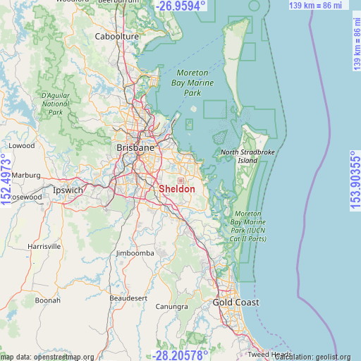
Sheldon GPS coordinates[2]
27° 35' 3.696" South, 153° 12' 1.512" East
| Map corner | latitude | longitude |
|---|---|---|
| Upper-left | -26.9594°, | 152.4973° |
| Center: | -27.58436°, | 153.20042° |
| Lower-right: | -28.20578°, | 153.90355° |
| Map W x H: | 138.6×138.6 km | = 86.1×86.1mi |
| max Lat: | -10.58257° ⇑20.2% North |
| Sheldon: | -27.58436° |
| min Lat: | ⇓79.8% South -43.31423° |
| min Long | Sheldon | max Long |
| 113.53327° | 153.20042° | 153.61246° |
| W 96.7%⇐ | ⇒3.3% E |
Elevation
Elevation of Sheldon is 47 m = 154 ft, and this is 75 m = 246 ft below average elevation for this country.
| Max E: |
1715 m = 5627 ft | 48.9% |
| Avg. | 122 m = 400 ft | |
| Sheldon | 47 m = 154 ft | |
Min E: |
-2 m = -7 ft | 51.1% |
See also: Australia elevation on elevation.city.
Geographical zone
Sheldon is located in South temperate zone (between Tropic of Capricorn and the Antarctic Circle). Distance of this Southern Tropic circle is 461.2 km =286.6 mi to North.| Distance of | km | miles | from Sheldon |
|---|---|---|---|
| Equator | 3067.1 | 1905.8 | to North |
| Tropic Capricorn | 461.2 | 286.6 | to North |
| Antarctic Circle | 4334.1 | 2693.1 | to South |
| South Pole | 6940 | 4312.3 | to South |


Nearby cities:
15 places around Sheldon: (largest is in red/bold)
• Alexandra Hills
6.4 km =4 mi,  25°
25°
• Burbank
6.1 km =3.8 mi,  301°
301°
• Capalaba
4.6 km =2.9 mi,  3°
3°
• Cleveland
9 km =5.6 mi,  44°
44°
• Daisy Hill
6.6 km =4.1 mi,  219°
219°
• Mackenzie
9.1 km =5.7 mi, 299°
• Mount Cotton
6.3 km =3.9 mi,  149°
149°
• Ormiston
9 km =5.6 mi, 32°
• Rochedale
6.9 km =4.3 mi,  286°
286°
• Rochedale South
7.7 km =4.8 mi,  260°
260°
• Shailer Park
7.6 km =4.7 mi,  197°
197°
• Slacks Creek
8.8 km =5.5 mi,  214°
214°
• Springwood
7.7 km =4.8 mi,  246°
246°
• Thornlands
7 km =4.3 mi,  64°
64°
• Underwood
9.2 km =5.7 mi, 252°
Sources, notices
• [Note1] Compared only with cities in Australia existing in our database
• [Src1] Map data: © OpenStreetMap contributors (CC-BY-SA)
• [Src2] Other city data from geonames.org with taken over terms of usage.
• [Src3] Geographical zone / Annual Mean Temperature by Robert A. Rohde @ Wikipedia
