Merrimac geodata
Merrimac (Queensland) is a section of populated place; located in Australia in Australia/Brisbane (GMT+10) time zone. With population of 7,005 people, there are 977 cities with bigger population in this country. Compared to other cities in Australia, 75.7% of cities are located further ↓South; 98.3% of cities are located further ←West and 98.8% of cities have higher elevation than Merrimac. Note1


Merrimac GPS coordinates[2]
28° 3' 3.06" South, 153° 22' 23.052" East
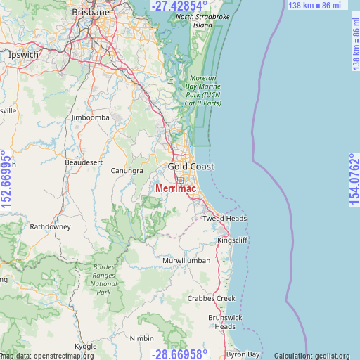
| Map corner | latitude | longitude |
|---|---|---|
| Upper-left | -27.42854°, | 152.66995° |
| Center: | -28.05085°, | 153.37307° |
| Lower-right: | -28.66958°, | 154.0762° |
| Map W x H: | 138×138 km | = 85.7×85.7mi |
| max Lat: | -10.58257° ⇑24.3% North |
| Merrimac: | -28.05085° |
| min Lat: | ⇓75.7% South -43.31423° |
| min Long | Merrimac | max Long |
| 113.53327° | 153.37307° | 153.61246° |
| W 98.3%⇐ | ⇒1.7% E |
Elevation
Elevation of Merrimac is 3 m = 10 ft, and this is 119 m = 390 ft below average elevation for this country.
| Max E: |
1715 m = 5627 ft | 98.8% |
| Avg. | 122 m = 400 ft | |
| Merrimac | 3 m = 10 ft | |
Min E: |
-2 m = -7 ft | 1.2% |
See also: Australia elevation on elevation.city.
Geographical zone
Merrimac is located in South temperate zone (between Tropic of Capricorn and the Antarctic Circle). Distance of this Southern Tropic circle is 513 km =318.8 mi to North.| Distance of | km | miles | from Merrimac |
|---|---|---|---|
| Equator | 3119 | 1938.1 | to North |
| Tropic Capricorn | 513 | 318.8 | to North |
| Antarctic Circle | 4282.2 | 2660.8 | to South |
| South Pole | 6888.1 | 4280.1 | to South |


Nearby cities:
15 places around Merrimac: (largest is in red/bold)
• Ashmore
6.9 km =4.3 mi,  2°
2°
• Benowa
5 km =3.1 mi,  14°
14°
• Broadbeach
6.5 km =4 mi,  66°
66°
• Broadbeach Waters
5.4 km =3.4 mi, 70°
• Bundall
5.4 km =3.4 mi,  35°
35°
• Carrara
3.3 km =2.1 mi,  348°
348°
• Clear Island Waters
2.5 km =1.6 mi,  95°
95°
• Highland Park
5.7 km =3.5 mi,  316°
316°
• Mermaid Beach
6.1 km =3.8 mi,  82°
82°
• Mermaid Waters
5.7 km =3.5 mi,  88°
88°
• Mudgeeraba
3.7 km =2.3 mi,  189°
189°
• Robina
3 km =1.9 mi,  138°
138°
• Tallai
4.9 km =3 mi,  252°
252°
• Varsity Lakes
5.8 km =3.6 mi, 138°
• Worongary
2.3 km =1.4 mi,  272°
272°
Sources, notices
• [Note1] Compared only with cities in Australia existing in our database
• [Src1] Map data: © OpenStreetMap contributors (CC-BY-SA)
• [Src2] Other city data from geonames.org with taken over terms of usage.
• [Src3] Geographical zone / Annual Mean Temperature by Robert A. Rohde @ Wikipedia
