Carrara geodata
Carrara (Queensland) is a section of populated place; located in Australia in Australia/Brisbane (GMT+10) time zone. With population of 11,970 people, there are 422 cities with bigger population in this country. Compared to other cities in Australia, 76% of cities are located further ↓South; 98.3% of cities are located further ←West and 99.9% of cities have higher elevation than Carrara. Note1


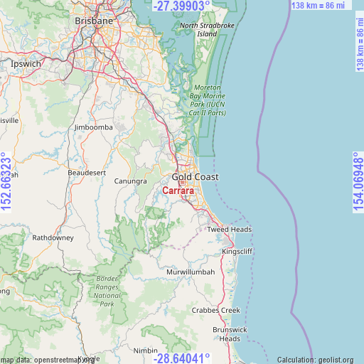
Carrara GPS coordinates[2]
28° 1' 17.436" South, 153° 21' 58.86" East
| Map corner | latitude | longitude |
|---|---|---|
| Upper-left | -27.39903°, | 152.66323° |
| Center: | -28.02151°, | 153.36635° |
| Lower-right: | -28.64041°, | 154.06948° |
| Map W x H: | 138×138 km | = 85.7×85.7mi |
| max Lat: | -10.58257° ⇑24% North |
| Carrara: | -28.02151° |
| min Lat: | ⇓76% South -43.31423° |
| min Long | Carrara | max Long |
| 113.53327° | 153.36635° | 153.61246° |
| W 98.3%⇐ | ⇒1.7% E |
Elevation
Elevation of Carrara is 1 m = 3 ft, and this is 121 m = 397 ft below average elevation for this country.
| Max E: |
1715 m = 5627 ft | 99.9% |
| Avg. | 122 m = 400 ft | |
| Carrara | 1 m = 3 ft | |
Min E: |
-2 m = -7 ft | 0.1% |
See also: Australia elevation on elevation.city.
Geographical zone
Carrara is located in South temperate zone (between Tropic of Capricorn and the Antarctic Circle). Distance of this Southern Tropic circle is 509.8 km =316.8 mi to North.| Distance of | km | miles | from Carrara |
|---|---|---|---|
| Equator | 3115.7 | 1936 | to North |
| Tropic Capricorn | 509.8 | 316.8 | to North |
| Antarctic Circle | 4285.5 | 2662.9 | to South |
| South Pole | 6891.4 | 4282.1 | to South |


Nearby cities:
15 places around Carrara: (largest is in red/bold)
• Ashmore
3.8 km =2.4 mi,  15°
15°
• Benowa
2.5 km =1.6 mi,  51°
51°
• Broadbeach
6.6 km =4.1 mi,  96°
96°
• Broadbeach Waters
5.9 km =3.7 mi, 104°
• Bundall
3.9 km =2.4 mi,  72°
72°
• Clear Island Waters
4.7 km =2.9 mi,  138°
138°
• Gilston
6.6 km =4.1 mi,  258°
258°
• Highland Park
3.4 km =2.1 mi,  284°
284°
• Merrimac
3.3 km =2.1 mi,  168°
168°
• Molendinar
5.3 km =3.3 mi,  353°
353°
• Nerang
4.6 km =2.9 mi,  320°
320°
• Robina
6.1 km =3.8 mi,  154°
154°
• Surfers Paradise
6.6 km =4.1 mi, 71°
• Tallai
6.2 km =3.9 mi,  219°
219°
• Worongary
3.6 km =2.2 mi,  206°
206°
Sources, notices
• [Note1] Compared only with cities in Australia existing in our database
• [Src1] Map data: © OpenStreetMap contributors (CC-BY-SA)
• [Src2] Other city data from geonames.org with taken over terms of usage.
• [Src3] Geographical zone / Annual Mean Temperature by Robert A. Rohde @ Wikipedia
