Atwell geodata
Atwell (Western Australia) is a section of populated place; located in Australia in Australia/Perth (GMT+8) time zone. With population of 8,926 people, there are 709 cities with bigger population in this country. Compared to other cities in Australia, 63.1% of cities are located further ↓South; 94.5% of cities are located further →East and 63.7% of cities have higher elevation than Atwell. Note1


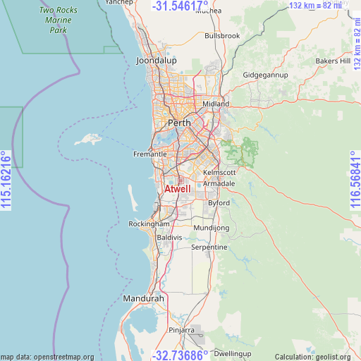
Atwell GPS coordinates[2]
32° 8' 36.456" South, 115° 51' 55.008" East
| Map corner | latitude | longitude |
|---|---|---|
| Upper-left | -31.54617°, | 115.16216° |
| Center: | -32.14346°, | 115.86528° |
| Lower-right: | -32.73686°, | 116.56841° |
| Map W x H: | 132.4×132.4 km | = 82.3×82.3mi |
| max Lat: | -10.58257° ⇑36.9% North |
| Atwell: | -32.14346° |
| min Lat: | ⇓63.1% South -43.31423° |
| min Long | Atwell | max Long |
| 113.53327° | 115.86528° | 153.61246° |
| W 5.5%⇐ | ⇒94.5% E |
Elevation
Elevation of Atwell is 28 m = 92 ft, and this is 94 m = 308 ft below average elevation for this country.
| Max E: |
1715 m = 5627 ft | 63.7% |
| Avg. | 122 m = 400 ft | |
| Atwell | 28 m = 92 ft | |
Min E: |
-2 m = -7 ft | 36.3% |
See also: Australia elevation on elevation.city.
Geographical zone
Atwell is located in South temperate zone (between Tropic of Capricorn and the Antarctic Circle). Distance of this Southern Tropic circle is 968.1 km =601.5 mi to North.| Distance of | km | miles | from Atwell |
|---|---|---|---|
| Equator | 3574 | 2220.8 | to North |
| Tropic Capricorn | 968.1 | 601.5 | to North |
| Antarctic Circle | 3827.2 | 2378.1 | to South |
| South Pole | 6433 | 3997.3 | to South |


Nearby cities:
15 places around Atwell: (largest is in red/bold)
• Aubin Grove
2.6 km =1.6 mi,  185°
185°
• Banjup
2 km =1.2 mi,  84°
84°
• Beeliar
5.7 km =3.5 mi,  281°
281°
• Bibra Lake
6.7 km =4.2 mi,  319°
319°
• City of Cockburn
5 km =3.1 mi,  336°
336°
• Cockburn Central
3 km =1.9 mi,  326°
326°
• Forrestdale
6.6 km =4.1 mi,  101°
101°
• Hammond Park
3.1 km =1.9 mi,  206°
206°
• Jandakot
4.7 km =2.9 mi,  6°
6°
• North Lake
7.4 km =4.6 mi, 337°
• Piara Waters
4.9 km =3 mi, 76°
• South Lake
4.4 km =2.7 mi, 325°
• Success
1.4 km =0.9 mi,  272°
272°
• Wandi
5.7 km =3.5 mi,  169°
169°
• Yangebup
5.3 km =3.3 mi,  298°
298°
Sources, notices
• [Note1] Compared only with cities in Australia existing in our database
• [Src1] Map data: © OpenStreetMap contributors (CC-BY-SA)
• [Src2] Other city data from geonames.org with taken over terms of usage.
• [Src3] Geographical zone / Annual Mean Temperature by Robert A. Rohde @ Wikipedia
