Jandakot geodata
Jandakot (Western Australia) is a section of populated place; located in Australia in Australia/Perth (GMT+8) time zone. With population of 2,572 people, there are 2521 cities with bigger population in this country. Compared to other cities in Australia, 63.6% of cities are located further ↓South; 94.2% of cities are located further →East and 55.2% of cities have higher elevation than Jandakot. Note1


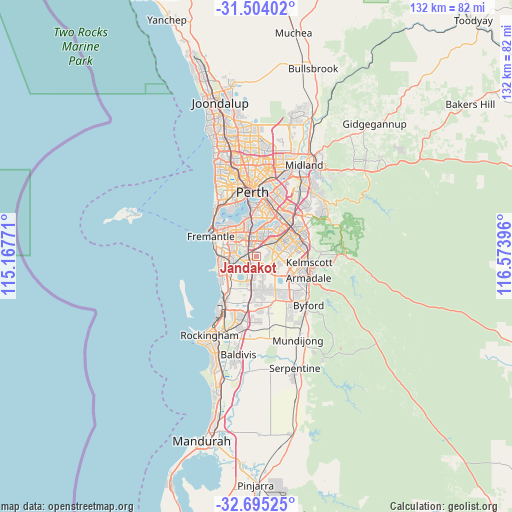
Jandakot GPS coordinates[2]
32° 6' 5.688" South, 115° 52' 14.988" East
| Map corner | latitude | longitude |
|---|---|---|
| Upper-left | -31.50402°, | 115.16771° |
| Center: | -32.10158°, | 115.87083° |
| Lower-right: | -32.69525°, | 116.57396° |
| Map W x H: | 132.5×132.5 km | = 82.3×82.3mi |
| max Lat: | -10.58257° ⇑36.4% North |
| Jandakot: | -32.10158° |
| min Lat: | ⇓63.6% South -43.31423° |
| min Long | Jandakot | max Long |
| 113.53327° | 115.87083° | 153.61246° |
| W 5.8%⇐ | ⇒94.2% E |
Elevation
Elevation of Jandakot is 38 m = 125 ft, and this is 84 m = 276 ft below average elevation for this country.
| Max E: |
1715 m = 5627 ft | 55.2% |
| Avg. | 122 m = 400 ft | |
| Jandakot | 38 m = 125 ft | |
Min E: |
-2 m = -7 ft | 44.8% |
See also: Australia elevation on elevation.city.
Geographical zone
Jandakot is located in South temperate zone (between Tropic of Capricorn and the Antarctic Circle). Distance of this Southern Tropic circle is 963.4 km =598.6 mi to North.| Distance of | km | miles | from Jandakot |
|---|---|---|---|
| Equator | 3569.4 | 2217.9 | to North |
| Tropic Capricorn | 963.4 | 598.6 | to North |
| Antarctic Circle | 3831.8 | 2381 | to South |
| South Pole | 6437.7 | 4000.2 | to South |


Nearby cities:
15 places around Jandakot: (largest is in red/bold)
• Atwell
4.7 km =2.9 mi,  186°
186°
• Banjup
4.7 km =2.9 mi,  161°
161°
• Bateman
5.6 km =3.5 mi,  336°
336°
• Bibra Lake
4.9 km =3 mi,  275°
275°
• Bull Creek
5.1 km =3.2 mi,  351°
351°
• City of Cockburn
2.5 km =1.6 mi,  267°
267°
• Cockburn Central
3.1 km =1.9 mi,  224°
224°
• Leeming
3 km =1.9 mi, 351°
• Murdoch
4.7 km =2.9 mi,  318°
318°
• North Lake
4 km =2.5 mi,  303°
303°
• Piara Waters
5.6 km =3.5 mi,  129°
129°
• South Lake
3.2 km =2 mi,  250°
250°
• Success
5 km =3.1 mi,  203°
203°
• Willetton
5.7 km =3.5 mi,  16°
16°
• Yangebup
5.6 km =3.5 mi, 247°
Sources, notices
• [Note1] Compared only with cities in Australia existing in our database
• [Src1] Map data: © OpenStreetMap contributors (CC-BY-SA)
• [Src2] Other city data from geonames.org with taken over terms of usage.
• [Src3] Geographical zone / Annual Mean Temperature by Robert A. Rohde @ Wikipedia
