Hillcrest geodata
Hillcrest (Queensland) is a section of populated place; located in Australia in Australia/Brisbane (GMT+10) time zone. With population of 5,603 people, there are 1310 cities with bigger population in this country. Compared to other cities in Australia, 78% of cities are located further ↓South; 92.1% of cities are located further ←West and 56.3% of cities have lower elevation than Hillcrest. Note1


Hillcrest GPS coordinates[2]
27° 40' 6.852" South, 153° 1' 34.104" East
| Map corner | latitude | longitude |
|---|---|---|
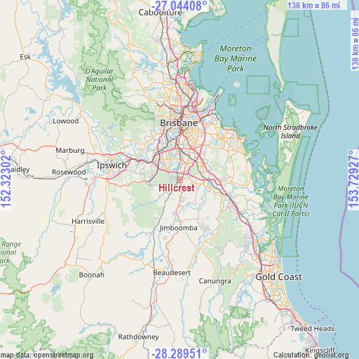
| Upper-left | -27.04408°, | 152.32302° |
| Center: | -27.66857°, | 153.02614° |
| Lower-right: | -28.28951°, | 153.72927° |
| Map W x H: | 138.5×138.5 km | = 86.1×86.1mi |
| max Lat: | -10.58257° ⇑22% North |
| Hillcrest: | -27.66857° |
| min Lat: | ⇓78% South -43.31423° |
| min Long | Hillcrest | max Long |
| 113.53327° | 153.02614° | 153.61246° |
| W 92.1%⇐ | ⇒7.9% E |
Elevation
Elevation of Hillcrest is 56 m = 184 ft, and this is 66 m = 217 ft below average elevation for this country.
| Max E: |
1715 m = 5627 ft | 43.7% |
| Avg. | 122 m = 400 ft | |
| Hillcrest | 56 m = 184 ft | |
Min E: |
-2 m = -7 ft | 56.3% |
See also: Australia elevation on elevation.city.
Geographical zone
Hillcrest is located in South temperate zone (between Tropic of Capricorn and the Antarctic Circle). Distance of this Southern Tropic circle is 470.5 km =292.4 mi to North.| Distance of | km | miles | from Hillcrest |
|---|---|---|---|
| Equator | 3076.5 | 1911.6 | to North |
| Tropic Capricorn | 470.5 | 292.4 | to North |
| Antarctic Circle | 4324.7 | 2687.2 | to South |
| South Pole | 6930.6 | 4306.5 | to South |


Nearby cities:
15 places around Hillcrest: (largest is in red/bold)
• Algester
6.2 km =3.9 mi,  5°
5°
• Berrinba
5.3 km =3.3 mi,  77°
77°
• Boronia Heights
2.3 km =1.4 mi,  196°
196°
• Calamvale
5.5 km =3.4 mi,  23°
23°
• Crestmead
6.1 km =3.8 mi,  110°
110°
• Drewvale
3.6 km =2.2 mi,  50°
50°
• Forestdale
2.3 km =1.4 mi,  284°
284°
• Greenbank
6.8 km =4.2 mi,  218°
218°
• Heathwood
5.3 km =3.3 mi,  315°
315°
• Heritage Park
3.8 km =2.4 mi, 114°
• Park Ridge
5.4 km =3.4 mi,  172°
172°
• Park Ridge South
6.5 km =4 mi, 173°
• Parkinson
2.8 km =1.7 mi, 7°
• Regents Park
1.8 km =1.1 mi,  120°
120°
• Stretton
6.5 km =4 mi,  37°
37°
Sources, notices
• [Note1] Compared only with cities in Australia existing in our database
• [Src1] Map data: © OpenStreetMap contributors (CC-BY-SA)
• [Src2] Other city data from geonames.org with taken over terms of usage.
• [Src3] Geographical zone / Annual Mean Temperature by Robert A. Rohde @ Wikipedia
