Berrinba geodata
Berrinba (Queensland) is a section of populated place; located in Australia in Australia/Brisbane (GMT+10) time zone. With population of 1,328 people, there are 3450 cities with bigger population in this country. Compared to other cities in Australia, 78.3% of cities are located further ↓South; 94.2% of cities are located further ←West and 62.8% of cities have higher elevation than Berrinba. Note1


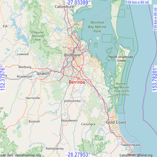
Berrinba GPS coordinates[2]
27° 39' 30.708" South, 153° 4' 43.968" East
| Map corner | latitude | longitude |
|---|---|---|
| Upper-left | -27.03399°, | 152.37576° |
| Center: | -27.65853°, | 153.07888° |
| Lower-right: | -28.27953°, | 153.78201° |
| Map W x H: | 138.5×138.5 km | = 86.1×86.1mi |
| max Lat: | -10.58257° ⇑21.7% North |
| Berrinba: | -27.65853° |
| min Lat: | ⇓78.3% South -43.31423° |
| min Long | Berrinba | max Long |
| 113.53327° | 153.07888° | 153.61246° |
| W 94.2%⇐ | ⇒5.8% E |
Elevation
Elevation of Berrinba is 29 m = 95 ft, and this is 93 m = 305 ft below average elevation for this country.
| Max E: |
1715 m = 5627 ft | 62.8% |
| Avg. | 122 m = 400 ft | |
| Berrinba | 29 m = 95 ft | |
Min E: |
-2 m = -7 ft | 37.2% |
See also: Australia elevation on elevation.city.
Geographical zone
Berrinba is located in South temperate zone (between Tropic of Capricorn and the Antarctic Circle). Distance of this Southern Tropic circle is 469.4 km =291.7 mi to North.| Distance of | km | miles | from Berrinba |
|---|---|---|---|
| Equator | 3075.3 | 1910.9 | to North |
| Tropic Capricorn | 469.4 | 291.7 | to North |
| Antarctic Circle | 4325.8 | 2687.9 | to South |
| South Pole | 6931.7 | 4307.2 | to South |


Nearby cities:
15 places around Berrinba: (largest is in red/bold)
• Calamvale
5 km =3.1 mi,  322°
322°
• Crestmead
3.3 km =2.1 mi,  170°
170°
• Drewvale
2.7 km =1.7 mi,  296°
296°
• Heritage Park
3.2 km =2 mi,  213°
213°
• Hillcrest
5.3 km =3.3 mi,  257°
257°
• Kingston
3.8 km =2.4 mi,  103°
103°
• Kuraby
5.9 km =3.7 mi,  14°
14°
• Logan Central
3.2 km =2 mi,  59°
59°
• Logan City
3.7 km =2.3 mi,  54°
54°
• Loganlea
5.8 km =3.6 mi,  108°
108°
• Marsden
2.5 km =1.6 mi,  132°
132°
• Parkinson
5.1 km =3.2 mi,  289°
289°
• Regents Park
4.2 km =2.6 mi,  241°
241°
• Stretton
4.2 km =2.6 mi,  342°
342°
• Woodridge
3.5 km =2.2 mi,  36°
36°
Sources, notices
• [Note1] Compared only with cities in Australia existing in our database
• [Src1] Map data: © OpenStreetMap contributors (CC-BY-SA)
• [Src2] Other city data from geonames.org with taken over terms of usage.
• [Src3] Geographical zone / Annual Mean Temperature by Robert A. Rohde @ Wikipedia
