Algester geodata
Algester (Queensland) is a section of populated place; located in Australia in Australia/Brisbane (GMT+10) time zone. With population of 8,330 people, there are 780 cities with bigger population in this country. Compared to other cities in Australia, 79.1% of cities are located further ↓South; 92.4% of cities are located further ←West and 57.6% of cities have higher elevation than Algester. Note1


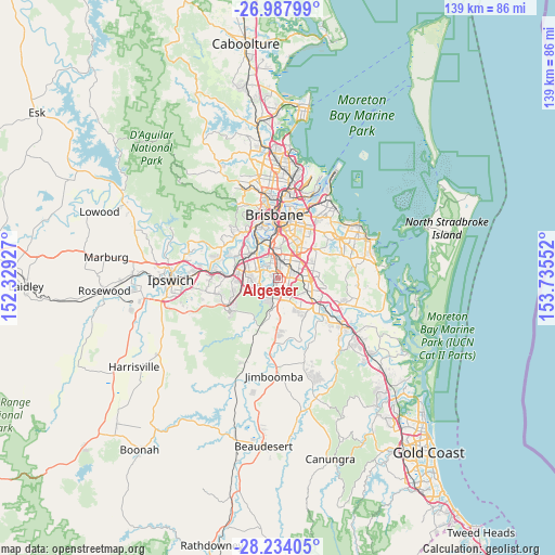
Algester GPS coordinates[2]
27° 36' 46.044" South, 153° 1' 56.604" East
| Map corner | latitude | longitude |
|---|---|---|
| Upper-left | -26.98799°, | 152.32927° |
| Center: | -27.61279°, | 153.03239° |
| Lower-right: | -28.23405°, | 153.73552° |
| Map W x H: | 138.5×138.6 km | = 86.1×86.1mi |
| max Lat: | -10.58257° ⇑20.9% North |
| Algester: | -27.61279° |
| min Lat: | ⇓79.1% South -43.31423° |
| min Long | Algester | max Long |
| 113.53327° | 153.03239° | 153.61246° |
| W 92.4%⇐ | ⇒7.6% E |
Elevation
Elevation of Algester is 35 m = 115 ft, and this is 87 m = 285 ft below average elevation for this country.
| Max E: |
1715 m = 5627 ft | 57.6% |
| Avg. | 122 m = 400 ft | |
| Algester | 35 m = 115 ft | |
Min E: |
-2 m = -7 ft | 42.4% |
See also: Australia elevation on elevation.city.
Geographical zone
Algester is located in South temperate zone (between Tropic of Capricorn and the Antarctic Circle). Distance of this Southern Tropic circle is 464.3 km =288.5 mi to North.| Distance of | km | miles | from Algester |
|---|---|---|---|
| Equator | 3070.3 | 1907.8 | to North |
| Tropic Capricorn | 464.3 | 288.5 | to North |
| Antarctic Circle | 4330.9 | 2691.1 | to South |
| South Pole | 6936.8 | 4310.3 | to South |


Nearby cities:
15 places around Algester: (largest is in red/bold)
• Acacia Ridge
3.3 km =2.1 mi,  1°
1°
• Archerfield
5.4 km =3.4 mi,  340°
340°
• Calamvale
1.9 km =1.2 mi,  127°
127°
• Coopers Plains
5.4 km =3.4 mi,  8°
8°
• Doolandella
4.6 km =2.9 mi,  269°
269°
• Drewvale
4.5 km =2.8 mi,  150°
150°
• Durack
5.3 km =3.3 mi,  299°
299°
• Heathwood
5 km =3.1 mi,  241°
241°
• Inala
6 km =3.7 mi,  286°
286°
• Parkinson
3.4 km =2.1 mi,  184°
184°
• Robertson
5.8 km =3.6 mi,  25°
25°
• Runcorn
4.7 km =2.9 mi,  68°
68°
• Stretton
3.5 km =2.2 mi,  107°
107°
• Sunnybank
4.6 km =2.9 mi,  37°
37°
• Sunnybank Hills
2.1 km =1.3 mi,  82°
82°
Sources, notices
• [Note1] Compared only with cities in Australia existing in our database
• [Src1] Map data: © OpenStreetMap contributors (CC-BY-SA)
• [Src2] Other city data from geonames.org with taken over terms of usage.
• [Src3] Geographical zone / Annual Mean Temperature by Robert A. Rohde @ Wikipedia
