Stretton geodata
Stretton (Queensland) is a section of populated place; located in Australia in Australia/Brisbane (GMT+10) time zone. With population of 4,284 people, there are 1688 cities with bigger population in this country. Compared to other cities in Australia, 78.9% of cities are located further ↓South; 93.7% of cities are located further ←West and 69.2% of cities have lower elevation than Stretton. Note1


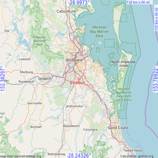
Stretton GPS coordinates[2]
27° 37' 19.38" South, 153° 3' 57.924" East
| Map corner | latitude | longitude |
|---|---|---|
| Upper-left | -26.9973°, | 152.36297° |
| Center: | -27.62205°, | 153.06609° |
| Lower-right: | -28.24326°, | 153.76922° |
| Map W x H: | 138.5×138.5 km | = 86.1×86.1mi |
| max Lat: | -10.58257° ⇑21.1% North |
| Stretton: | -27.62205° |
| min Lat: | ⇓78.9% South -43.31423° |
| min Long | Stretton | max Long |
| 113.53327° | 153.06609° | 153.61246° |
| W 93.7%⇐ | ⇒6.3% E |
Elevation
Elevation of Stretton is 98 m = 322 ft, and this is 24 m = 79 ft below average elevation for this country.
| Max E: |
1715 m = 5627 ft | 30.8% |
| Avg. | 122 m = 400 ft | |
| Stretton | 98 m = 322 ft | |
Min E: |
-2 m = -7 ft | 69.2% |
See also: Australia elevation on elevation.city.
Geographical zone
Stretton is located in South temperate zone (between Tropic of Capricorn and the Antarctic Circle). Distance of this Southern Tropic circle is 465.4 km =289.2 mi to North.| Distance of | km | miles | from Stretton |
|---|---|---|---|
| Equator | 3071.3 | 1908.4 | to North |
| Tropic Capricorn | 465.4 | 289.2 | to North |
| Antarctic Circle | 4329.9 | 2690.5 | to South |
| South Pole | 6935.8 | 4309.7 | to South |


Nearby cities:
15 places around Stretton: (largest is in red/bold)
• Acacia Ridge
5.4 km =3.4 mi,  323°
323°
• Algester
3.5 km =2.2 mi,  287°
287°
• Berrinba
4.2 km =2.6 mi,  162°
162°
• Calamvale
1.8 km =1.1 mi,  265°
265°
• Drewvale
3.1 km =1.9 mi,  201°
201°
• Eight Mile Plains
5.4 km =3.4 mi,  37°
37°
• Kuraby
3.2 km =2 mi,  58°
58°
• Logan Central
4.7 km =2.9 mi,  120°
120°
• Logan City
4.7 km =2.9 mi,  114°
114°
• Parkinson
4.3 km =2.7 mi,  236°
236°
• Runcorn
2.9 km =1.8 mi,  21°
21°
• Sunnybank
4.7 km =2.9 mi,  353°
353°
• Sunnybank Hills
1.8 km =1.1 mi, 317°
• Underwood
4.7 km =2.9 mi,  71°
71°
• Woodridge
3.6 km =2.2 mi, 110°
Sources, notices
• [Note1] Compared only with cities in Australia existing in our database
• [Src1] Map data: © OpenStreetMap contributors (CC-BY-SA)
• [Src2] Other city data from geonames.org with taken over terms of usage.
• [Src3] Geographical zone / Annual Mean Temperature by Robert A. Rohde @ Wikipedia
