Grindelwald geodata
Grindelwald (Tasmania) is a section of populated place; located in Australia in Australia/Hobart (GMT+11) time zone. With population of 951 people, there are 3894 cities with bigger population in this country. Compared to other cities in Australia, 97.3% of cities are located further ↑North; 53.1% of cities are located further →East and 80.4% of cities have lower elevation than Grindelwald. Note1


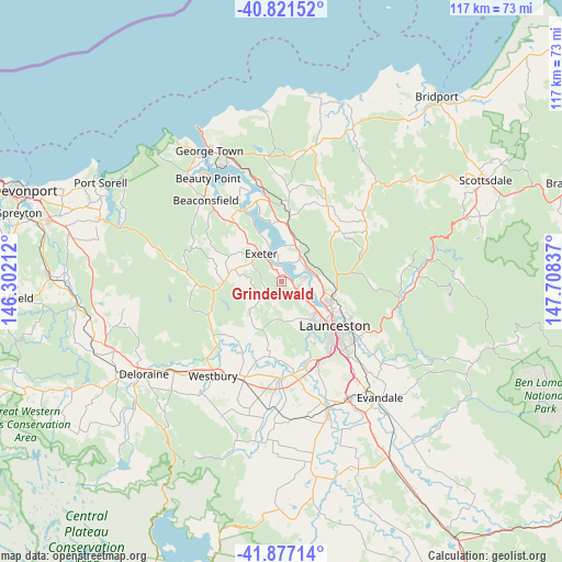
Grindelwald GPS coordinates[2]
41° 21' 5.292" South, 147° 0' 18.864" East
| Map corner | latitude | longitude |
|---|---|---|
| Upper-left | -40.82152°, | 146.30212° |
| Center: | -41.35147°, | 147.00524° |
| Lower-right: | -41.87714°, | 147.70837° |
| Map W x H: | 117.4×117.4 km | = 72.9×72.9mi |
| max Lat: | -10.58257° ⇑97.3% North |
| Grindelwald: | -41.35147° |
| min Lat: | ⇓2.7% South -43.31423° |
| min Long | Grindelwald | max Long |
| 113.53327° | 147.00524° | 153.61246° |
| W 46.9%⇐ | ⇒53.1% E |
Elevation
Elevation of Grindelwald is 185 m = 607 ft, and this is 63 m = 207 ft above average elevation for this country.
| Max E: |
1715 m = 5627 ft | 19.6% |
| Grindelwald | 185 m 607 ft | |
| Avg. | 122 m = 400 ft | |
Min E: |
-2 m = -7 ft | 80.4% |
See also: Australia elevation on elevation.city.
Geographical zone
Grindelwald is located in South temperate zone (between Tropic of Capricorn and the Antarctic Circle). Distance of this Southern Tropic circle is 1991.9 km =1237.7 mi to North.| Distance of | km | miles | from Grindelwald |
|---|---|---|---|
| Equator | 4597.9 | 2857 | to North |
| Tropic Capricorn | 1991.9 | 1237.7 | to North |
| Antarctic Circle | 2803.3 | 1741.9 | to South |
| South Pole | 5409.2 | 3361.1 | to South |


Nearby cities:
15 places around Grindelwald: (largest is in red/bold)
• Blackstone Heights
13.7 km =8.5 mi,  151°
151°
• Dilston
5.6 km =3.5 mi,  64°
64°
• Exeter
7.5 km =4.7 mi,  322°
322°
• Gravelly Beach
7.7 km =4.8 mi,  340°
340°
• Hillwood
12.1 km =7.5 mi,  351°
351°
• Invermay
13.2 km =8.2 mi,  125°
125°
• Launceston
14.5 km =9 mi, 131°
• Launceston city centre
14.3 km =8.9 mi, 129°
• Legana
3.7 km =2.3 mi,  115°
115°
• Mayfield
11.2 km =7 mi,  111°
111°
• Mowbray
13.4 km =8.3 mi, 115°
• Newnham
10 km =6.2 mi, 115°
• Riverside
8.6 km =5.3 mi, 153°
• Rocherlea
13.1 km =8.1 mi,  104°
104°
• Trevallyn
13.1 km =8.1 mi,  140°
140°
Sources, notices
• [Note1] Compared only with cities in Australia existing in our database
• [Src1] Map data: © OpenStreetMap contributors (CC-BY-SA)
• [Src2] Other city data from geonames.org with taken over terms of usage.
• [Src3] Geographical zone / Annual Mean Temperature by Robert A. Rohde @ Wikipedia
