Willetton geodata
Willetton (Western Australia) is a section of populated place; located in Australia in Australia/Perth (GMT+8) time zone. With population of 17,887 people, there are 199 cities with bigger population in this country. Compared to other cities in Australia, 64.1% of cities are located further ↓South; 94% of cities are located further →East and 70.9% of cities have higher elevation than Willetton. Note1


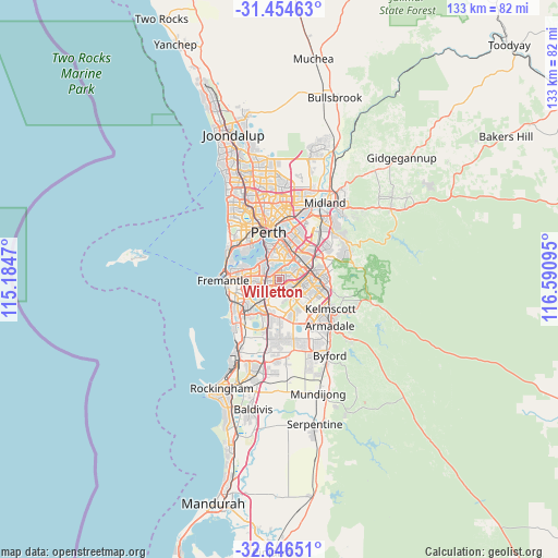
Willetton GPS coordinates[2]
32° 3' 9.036" South, 115° 53' 16.152" East
| Map corner | latitude | longitude |
|---|---|---|
| Upper-left | -31.45463°, | 115.1847° |
| Center: | -32.05251°, | 115.88782° |
| Lower-right: | -32.64651°, | 116.59095° |
| Map W x H: | 132.5×132.5 km | = 82.3×82.3mi |
| max Lat: | -10.58257° ⇑35.9% North |
| Willetton: | -32.05251° |
| min Lat: | ⇓64.1% South -43.31423° |
| min Long | Willetton | max Long |
| 113.53327° | 115.88782° | 153.61246° |
| W 6%⇐ | ⇒94% E |
Elevation
Elevation of Willetton is 22 m = 72 ft, and this is 100 m = 328 ft below average elevation for this country.
| Max E: |
1715 m = 5627 ft | 70.9% |
| Avg. | 122 m = 400 ft | |
| Willetton | 22 m = 72 ft | |
Min E: |
-2 m = -7 ft | 29.1% |
See also: Australia elevation on elevation.city.
Geographical zone
Willetton is located in South temperate zone (between Tropic of Capricorn and the Antarctic Circle). Distance of this Southern Tropic circle is 958 km =595.3 mi to North.| Distance of | km | miles | from Willetton |
|---|---|---|---|
| Equator | 3563.9 | 2214.5 | to North |
| Tropic Capricorn | 958 | 595.3 | to North |
| Antarctic Circle | 3837.3 | 2384.4 | to South |
| South Pole | 6443.2 | 4003.6 | to South |


Nearby cities:
15 places around Willetton: (largest is in red/bold)
• Bateman
3.8 km =2.4 mi,  265°
265°
• Brentwood
3.5 km =2.2 mi,  286°
286°
• Bull Creek
2.4 km =1.5 mi,  260°
260°
• Canning Vale
2.9 km =1.8 mi,  102°
102°
• Ferndale
3.8 km =2.4 mi,  59°
59°
• Leeming
3.2 km =2 mi,  219°
219°
• Lynwood
4.1 km =2.5 mi,  70°
70°
• Mount Pleasant
3.8 km =2.4 mi, 291°
• Parkwood
2.9 km =1.8 mi,  82°
82°
• Riverton
2.2 km =1.4 mi,  27°
27°
• Rossmoyne
2.4 km =1.5 mi,  307°
307°
• Salter Point
3.8 km =2.4 mi,  326°
326°
• Shelley
2.6 km =1.6 mi,  357°
357°
• Waterford
4.1 km =2.5 mi, 358°
• Wilson
4.2 km =2.6 mi, 32°
Sources, notices
• [Note1] Compared only with cities in Australia existing in our database
• [Src1] Map data: © OpenStreetMap contributors (CC-BY-SA)
• [Src2] Other city data from geonames.org with taken over terms of usage.
• [Src3] Geographical zone / Annual Mean Temperature by Robert A. Rohde @ Wikipedia
