Tranmere geodata
Tranmere (South Australia) is a section of populated place; located in Australia in Australia/Adelaide (GMT+10.5) time zone. With population of 3,701 people, there are 1918 cities with bigger population in this country. Compared to other cities in Australia, 68.4% of cities are located further ↑North; 79.1% of cities are located further →East and 69.1% of cities have lower elevation than Tranmere. Note1


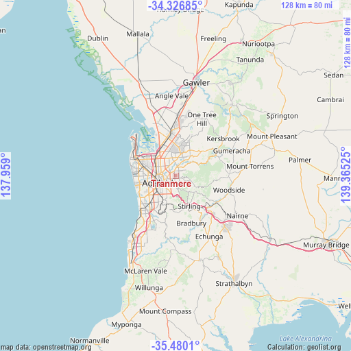
Tranmere GPS coordinates[2]
34° 54' 19.8" South, 138° 39' 43.632" East
| Map corner | latitude | longitude |
|---|---|---|
| Upper-left | -34.32685°, | 137.959° |
| Center: | -34.9055°, | 138.66212° |
| Lower-right: | -35.4801°, | 139.36525° |
| Map W x H: | 128.2×128.2 km | = 79.7×79.7mi |
| max Lat: | -10.58257° ⇑68.4% North |
| Tranmere: | -34.9055° |
| min Lat: | ⇓31.6% South -43.31423° |
| min Long | Tranmere | max Long |
| 113.53327° | 138.66212° | 153.61246° |
| W 20.9%⇐ | ⇒79.1% E |
Elevation
Elevation of Tranmere is 97 m = 318 ft, and this is 25 m = 82 ft below average elevation for this country.
| Max E: |
1715 m = 5627 ft | 30.9% |
| Avg. | 122 m = 400 ft | |
| Tranmere | 97 m = 318 ft | |
Min E: |
-2 m = -7 ft | 69.1% |
See also: Australia elevation on elevation.city.
Geographical zone
Tranmere is located in South temperate zone (between Tropic of Capricorn and the Antarctic Circle). Distance of this Southern Tropic circle is 1275.2 km =792.4 mi to North.| Distance of | km | miles | from Tranmere |
|---|---|---|---|
| Equator | 3881.1 | 2411.6 | to North |
| Tropic Capricorn | 1275.2 | 792.4 | to North |
| Antarctic Circle | 3520 | 2187.2 | to South |
| South Pole | 6125.9 | 3806.5 | to South |


Nearby cities:
15 places around Tranmere: (largest is in red/bold)
• Beulah Park
2.1 km =1.3 mi,  228°
228°
• Evandale
2.4 km =1.5 mi,  269°
269°
• Felixstow
2.3 km =1.4 mi,  322°
322°
• Firle
0.8 km =0.5 mi,  277°
277°
• Glynde
1.4 km =0.9 mi, 320°
• Hectorville
1.6 km =1 mi,  349°
349°
• Kensington Gardens
2.3 km =1.4 mi,  181°
181°
• Kensington Park
1.8 km =1.1 mi,  203°
203°
• Magill
1.2 km =0.7 mi,  108°
108°
• Maylands
2.4 km =1.5 mi,  254°
254°
• Payneham
2.2 km =1.4 mi,  295°
295°
• Payneham South
1.6 km =1 mi, 272°
• Rosslyn Park
2.2 km =1.4 mi,  146°
146°
• St Morris
1 km =0.6 mi, 231°
• Trinity Gardens
2.1 km =1.3 mi,  242°
242°
Sources, notices
• [Note1] Compared only with cities in Australia existing in our database
• [Src1] Map data: © OpenStreetMap contributors (CC-BY-SA)
• [Src2] Other city data from geonames.org with taken over terms of usage.
• [Src3] Geographical zone / Annual Mean Temperature by Robert A. Rohde @ Wikipedia
