Felixstow geodata
Felixstow (South Australia) is a section of populated place; located in Australia in Australia/Adelaide (GMT+10.5) time zone. With population of 2,259 people, there are 2723 cities with bigger population in this country. Compared to other cities in Australia, 67.8% of cities are located further ↑North; 79.6% of cities are located further →East and 54.5% of cities have lower elevation than Felixstow. Note1


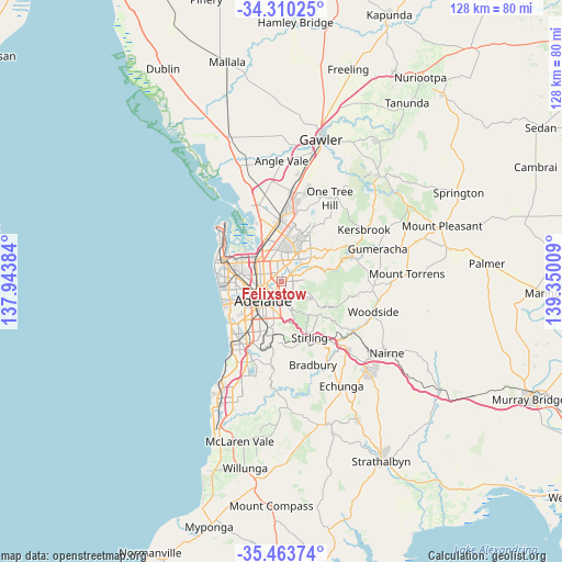
Felixstow GPS coordinates[2]
34° 53' 20.472" South, 138° 38' 49.056" East
| Map corner | latitude | longitude |
|---|---|---|
| Upper-left | -34.31025°, | 137.94384° |
| Center: | -34.88902°, | 138.64696° |
| Lower-right: | -35.46374°, | 139.35009° |
| Map W x H: | 128.3×128.3 km | = 79.7×79.7mi |
| max Lat: | -10.58257° ⇑67.8% North |
| Felixstow: | -34.88902° |
| min Lat: | ⇓32.2% South -43.31423° |
| min Long | Felixstow | max Long |
| 113.53327° | 138.64696° | 153.61246° |
| W 20.4%⇐ | ⇒79.6% E |
Elevation
Elevation of Felixstow is 52 m = 171 ft, and this is 70 m = 230 ft below average elevation for this country.
| Max E: |
1715 m = 5627 ft | 45.5% |
| Avg. | 122 m = 400 ft | |
| Felixstow | 52 m = 171 ft | |
Min E: |
-2 m = -7 ft | 54.5% |
See also: Australia elevation on elevation.city.
Geographical zone
Felixstow is located in South temperate zone (between Tropic of Capricorn and the Antarctic Circle). Distance of this Southern Tropic circle is 1273.4 km =791.3 mi to North.| Distance of | km | miles | from Felixstow |
|---|---|---|---|
| Equator | 3879.3 | 2410.5 | to North |
| Tropic Capricorn | 1273.4 | 791.3 | to North |
| Antarctic Circle | 3521.9 | 2188.4 | to South |
| South Pole | 6127.8 | 3807.6 | to South |


Nearby cities:
15 places around Felixstow: (largest is in red/bold)
• Campbelltown
1.9 km =1.2 mi,  70°
70°
• Evandale
2.1 km =1.3 mi,  209°
209°
• Firle
1.8 km =1.1 mi,  161°
161°
• Glynde
0.9 km =0.6 mi,  146°
146°
• Hampstead Gardens
2.3 km =1.4 mi,  314°
314°
• Hectorville
1.1 km =0.7 mi,  104°
104°
• Joslin
2.2 km =1.4 mi,  237°
237°
• Klemzig
1.5 km =0.9 mi,  316°
316°
• Marden
1.1 km =0.7 mi,  228°
228°
• Payneham
1.1 km =0.7 mi, 212°
• Payneham South
1.8 km =1.1 mi,  187°
187°
• Royston Park
1.7 km =1.1 mi, 236°
• St Morris
2.5 km =1.6 mi,  166°
166°
• Tranmere
2.3 km =1.4 mi,  142°
142°
• Vale Park
1.8 km =1.1 mi,  280°
280°
Sources, notices
• [Note1] Compared only with cities in Australia existing in our database
• [Src1] Map data: © OpenStreetMap contributors (CC-BY-SA)
• [Src2] Other city data from geonames.org with taken over terms of usage.
• [Src3] Geographical zone / Annual Mean Temperature by Robert A. Rohde @ Wikipedia
