Hectorville geodata
Hectorville (South Australia) is a section of populated place; located in Australia in Australia/Adelaide (GMT+10.5) time zone. With population of 3,661 people, there are 1934 cities with bigger population in this country. Compared to other cities in Australia, 67.8% of cities are located further ↑North; 79.3% of cities are located further →East and 62.4% of cities have lower elevation than Hectorville. Note1


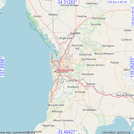
Hectorville GPS coordinates[2]
34° 53' 29.652" South, 138° 39' 32.112" East
| Map corner | latitude | longitude |
|---|---|---|
| Upper-left | -34.31282°, | 137.9558° |
| Center: | -34.89157°, | 138.65892° |
| Lower-right: | -35.46627°, | 139.36205° |
| Map W x H: | 128.3×128.3 km | = 79.7×79.7mi |
| max Lat: | -10.58257° ⇑67.8% North |
| Hectorville: | -34.89157° |
| min Lat: | ⇓32.2% South -43.31423° |
| min Long | Hectorville | max Long |
| 113.53327° | 138.65892° | 153.61246° |
| W 20.7%⇐ | ⇒79.3% E |
Elevation
Elevation of Hectorville is 71 m = 233 ft, and this is 51 m = 167 ft below average elevation for this country.
| Max E: |
1715 m = 5627 ft | 37.6% |
| Avg. | 122 m = 400 ft | |
| Hectorville | 71 m = 233 ft | |
Min E: |
-2 m = -7 ft | 62.4% |
See also: Australia elevation on elevation.city.
Geographical zone
Hectorville is located in South temperate zone (between Tropic of Capricorn and the Antarctic Circle). Distance of this Southern Tropic circle is 1273.7 km =791.4 mi to North.| Distance of | km | miles | from Hectorville |
|---|---|---|---|
| Equator | 3879.6 | 2410.7 | to North |
| Tropic Capricorn | 1273.7 | 791.4 | to North |
| Antarctic Circle | 3521.6 | 2188.2 | to South |
| South Pole | 6127.5 | 3807.5 | to South |


Nearby cities:
15 places around Hectorville: (largest is in red/bold)
• Campbelltown
1.2 km =0.7 mi,  37°
37°
• Evandale
2.6 km =1.6 mi,  234°
234°
• Felixstow
1.1 km =0.7 mi,  284°
284°
• Firle
1.5 km =0.9 mi,  199°
199°
• Glynde
0.8 km =0.5 mi, 229°
• Klemzig
2.5 km =1.6 mi,  302°
302°
• Magill
2.4 km =1.5 mi,  143°
143°
• Marden
2 km =1.2 mi,  256°
256°
• Newton
2.4 km =1.5 mi,  63°
63°
• Paradise
2.2 km =1.4 mi,  24°
24°
• Payneham
1.8 km =1.1 mi,  249°
249°
• Payneham South
2 km =1.2 mi,  221°
221°
• Royston Park
2.6 km =1.6 mi, 255°
• St Morris
2.2 km =1.4 mi,  192°
192°
• Tranmere
1.6 km =1 mi,  169°
169°
Sources, notices
• [Note1] Compared only with cities in Australia existing in our database
• [Src1] Map data: © OpenStreetMap contributors (CC-BY-SA)
• [Src2] Other city data from geonames.org with taken over terms of usage.
• [Src3] Geographical zone / Annual Mean Temperature by Robert A. Rohde @ Wikipedia
