Kuraby geodata
Kuraby (Queensland) is a section of populated place; located in Australia in Australia/Brisbane (GMT+10) time zone. With population of 8,037 people, there are 831 cities with bigger population in this country. Compared to other cities in Australia, 79.4% of cities are located further ↓South; 94.6% of cities are located further ←West and 54.5% of cities have lower elevation than Kuraby. Note1


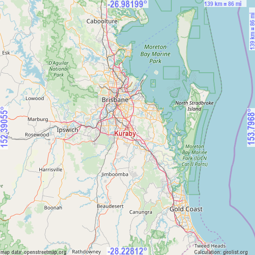
Kuraby GPS coordinates[2]
27° 36' 24.588" South, 153° 5' 37.212" East
| Map corner | latitude | longitude |
|---|---|---|
| Upper-left | -26.98199°, | 152.39055° |
| Center: | -27.60683°, | 153.09367° |
| Lower-right: | -28.22812°, | 153.7968° |
| Map W x H: | 138.6×138.6 km | = 86.1×86.1mi |
| max Lat: | -10.58257° ⇑20.6% North |
| Kuraby: | -27.60683° |
| min Lat: | ⇓79.4% South -43.31423° |
| min Long | Kuraby | max Long |
| 113.53327° | 153.09367° | 153.61246° |
| W 94.6%⇐ | ⇒5.4% E |
Elevation
Elevation of Kuraby is 52 m = 171 ft, and this is 70 m = 230 ft below average elevation for this country.
| Max E: |
1715 m = 5627 ft | 45.5% |
| Avg. | 122 m = 400 ft | |
| Kuraby | 52 m = 171 ft | |
Min E: |
-2 m = -7 ft | 54.5% |
See also: Australia elevation on elevation.city.
Geographical zone
Kuraby is located in South temperate zone (between Tropic of Capricorn and the Antarctic Circle). Distance of this Southern Tropic circle is 463.7 km =288.1 mi to North.| Distance of | km | miles | from Kuraby |
|---|---|---|---|
| Equator | 3069.6 | 1907.4 | to North |
| Tropic Capricorn | 463.7 | 288.1 | to North |
| Antarctic Circle | 4331.6 | 2691.5 | to South |
| South Pole | 6937.5 | 4310.8 | to South |


Nearby cities:
15 places around Kuraby: (largest is in red/bold)
• Calamvale
4.9 km =3 mi,  247°
247°
• Eight Mile Plains
2.7 km =1.7 mi,  13°
13°
• Logan Central
4.3 km =2.7 mi,  161°
161°
• Logan City
3.9 km =2.4 mi, 156°
• Macgregor
5.4 km =3.4 mi,  330°
330°
• Robertson
5.8 km =3.6 mi,  321°
321°
• Rochedale South
3.2 km =2 mi,  66°
66°
• Runcorn
1.9 km =1.2 mi,  302°
302°
• Springwood
3.5 km =2.2 mi,  99°
99°
• Stretton
3.2 km =2 mi,  238°
238°
• Sunnybank
4.4 km =2.7 mi,  312°
312°
• Sunnybank Hills
3.9 km =2.4 mi,  264°
264°
• Underwood
1.8 km =1.1 mi, 97°
• Upper Mount Gravatt
5.1 km =3.2 mi,  349°
349°
• Woodridge
3 km =1.9 mi,  168°
168°
Sources, notices
• [Note1] Compared only with cities in Australia existing in our database
• [Src1] Map data: © OpenStreetMap contributors (CC-BY-SA)
• [Src2] Other city data from geonames.org with taken over terms of usage.
• [Src3] Geographical zone / Annual Mean Temperature by Robert A. Rohde @ Wikipedia
