Runcorn geodata
Runcorn (Queensland) is a section of populated place; located in Australia in Australia/Brisbane (GMT+10) time zone. With population of 14,434 people, there are 298 cities with bigger population in this country. Compared to other cities in Australia, 79.6% of cities are located further ↓South; 94.1% of cities are located further ←West and 58% of cities have lower elevation than Runcorn. Note1


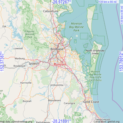
Runcorn GPS coordinates[2]
27° 35' 51.216" South, 153° 4' 37.164" East
| Map corner | latitude | longitude |
|---|---|---|
| Upper-left | -26.97267°, | 152.37387° |
| Center: | -27.59756°, | 153.07699° |
| Lower-right: | -28.21891°, | 153.78012° |
| Map W x H: | 138.6×138.6 km | = 86.1×86.1mi |
| max Lat: | -10.58257° ⇑20.4% North |
| Runcorn: | -27.59756° |
| min Lat: | ⇓79.6% South -43.31423° |
| min Long | Runcorn | max Long |
| 113.53327° | 153.07699° | 153.61246° |
| W 94.1%⇐ | ⇒5.9% E |
Elevation
Elevation of Runcorn is 59 m = 194 ft, and this is 63 m = 207 ft below average elevation for this country.
| Max E: |
1715 m = 5627 ft | 42% |
| Avg. | 122 m = 400 ft | |
| Runcorn | 59 m = 194 ft | |
Min E: |
-2 m = -7 ft | 58% |
See also: Australia elevation on elevation.city.
Geographical zone
Runcorn is located in South temperate zone (between Tropic of Capricorn and the Antarctic Circle). Distance of this Southern Tropic circle is 462.6 km =287.4 mi to North.| Distance of | km | miles | from Runcorn |
|---|---|---|---|
| Equator | 3068.6 | 1906.7 | to North |
| Tropic Capricorn | 462.6 | 287.4 | to North |
| Antarctic Circle | 4332.6 | 2692.2 | to South |
| South Pole | 6938.5 | 4311.4 | to South |


Nearby cities:
15 places around Runcorn: (largest is in red/bold)
• Acacia Ridge
4.6 km =2.9 mi,  290°
290°
• Algester
4.7 km =2.9 mi,  248°
248°
• Calamvale
4.1 km =2.5 mi,  225°
225°
• Eight Mile Plains
2.8 km =1.7 mi,  55°
55°
• Kuraby
1.9 km =1.2 mi,  122°
122°
• Macgregor
3.8 km =2.4 mi,  344°
344°
• Nathan
4.5 km =2.8 mi, 341°
• Robertson
4 km =2.5 mi,  331°
331°
• Rochedale South
4.6 km =2.9 mi,  86°
86°
• Stretton
2.9 km =1.8 mi,  201°
201°
• Sunnybank
2.5 km =1.6 mi,  320°
320°
• Sunnybank Hills
2.7 km =1.7 mi,  238°
238°
• Underwood
3.6 km =2.2 mi,  110°
110°
• Upper Mount Gravatt
4.1 km =2.5 mi,  10°
10°
• Woodridge
4.6 km =2.9 mi,  150°
150°
Sources, notices
• [Note1] Compared only with cities in Australia existing in our database
• [Src1] Map data: © OpenStreetMap contributors (CC-BY-SA)
• [Src2] Other city data from geonames.org with taken over terms of usage.
• [Src3] Geographical zone / Annual Mean Temperature by Robert A. Rohde @ Wikipedia
