Duncraig geodata
Duncraig (Western Australia) is a section of populated place; located in Australia in Australia/Perth (GMT+8) time zone. With population of 14,976 people, there are 276 cities with bigger population in this country. Compared to other cities in Australia, 67.8% of cities are located further ↓South; 96.7% of cities are located further →East and 53.5% of cities have lower elevation than Duncraig. Note1


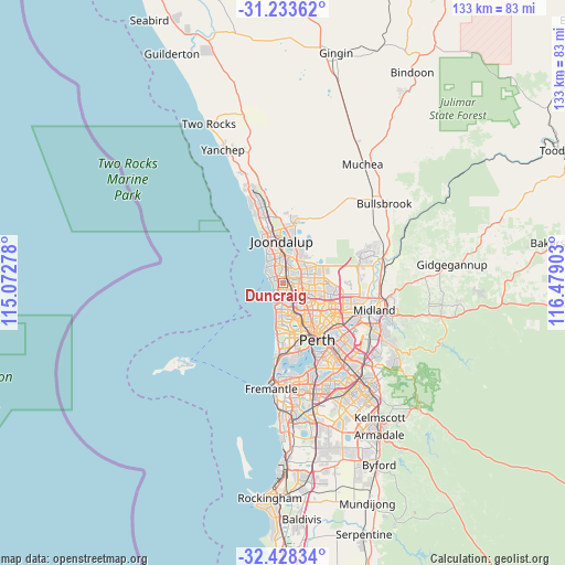
Duncraig GPS coordinates[2]
31° 49' 58.476" South, 115° 46' 33.24" East
| Map corner | latitude | longitude |
|---|---|---|
| Upper-left | -31.23362°, | 115.07278° |
| Center: | -31.83291°, | 115.7759° |
| Lower-right: | -32.42834°, | 116.47903° |
| Map W x H: | 132.8×132.8 km | = 82.5×82.5mi |
| max Lat: | -10.58257° ⇑32.2% North |
| Duncraig: | -31.83291° |
| min Lat: | ⇓67.8% South -43.31423° |
| min Long | Duncraig | max Long |
| 113.53327° | 115.7759° | 153.61246° |
| W 3.3%⇐ | ⇒96.7% E |
Elevation
Elevation of Duncraig is 50 m = 164 ft, and this is 72 m = 236 ft below average elevation for this country.
| Max E: |
1715 m = 5627 ft | 46.5% |
| Avg. | 122 m = 400 ft | |
| Duncraig | 50 m = 164 ft | |
Min E: |
-2 m = -7 ft | 53.5% |
See also: Australia elevation on elevation.city.
Geographical zone
Duncraig is located in South temperate zone (between Tropic of Capricorn and the Antarctic Circle). Distance of this Southern Tropic circle is 933.6 km =580.1 mi to North.| Distance of | km | miles | from Duncraig |
|---|---|---|---|
| Equator | 3539.5 | 2199.3 | to North |
| Tropic Capricorn | 933.6 | 580.1 | to North |
| Antarctic Circle | 3861.7 | 2399.5 | to South |
| South Pole | 6467.6 | 4018.8 | to South |


Nearby cities:
15 places around Duncraig: (largest is in red/bold)
• Carine
2.2 km =1.4 mi,  163°
163°
• Greenwood
2.6 km =1.6 mi,  75°
75°
• Gwelup
4.7 km =2.9 mi, 157°
• Hamersley
3.5 km =2.2 mi,  120°
120°
• Hillarys
4.4 km =2.7 mi,  310°
310°
• Kallaroo
5.1 km =3.2 mi,  335°
335°
• Karrinyup
4.4 km =2.7 mi,  178°
178°
• Kingsley
3.4 km =2.1 mi,  43°
43°
• Marmion
2 km =1.2 mi,  241°
241°
• North Beach
3.8 km =2.4 mi,  209°
209°
• Padbury
3 km =1.9 mi,  347°
347°
• Sorrento
2.4 km =1.5 mi,  290°
290°
• Trigg
4.4 km =2.7 mi,  203°
203°
• Warwick
3.2 km =2 mi,  103°
103°
• Watermans Bay
2.6 km =1.6 mi,  226°
226°
Sources, notices
• [Note1] Compared only with cities in Australia existing in our database
• [Src1] Map data: © OpenStreetMap contributors (CC-BY-SA)
• [Src2] Other city data from geonames.org with taken over terms of usage.
• [Src3] Geographical zone / Annual Mean Temperature by Robert A. Rohde @ Wikipedia
