Sorrento geodata
Sorrento (Western Australia) is a section of populated place; located in Australia in Australia/Perth (GMT+8) time zone. With population of 7,148 people, there are 955 cities with bigger population in this country. Compared to other cities in Australia, 68% of cities are located further ↓South; 97.5% of cities are located further →East and 63.7% of cities have higher elevation than Sorrento. Note1


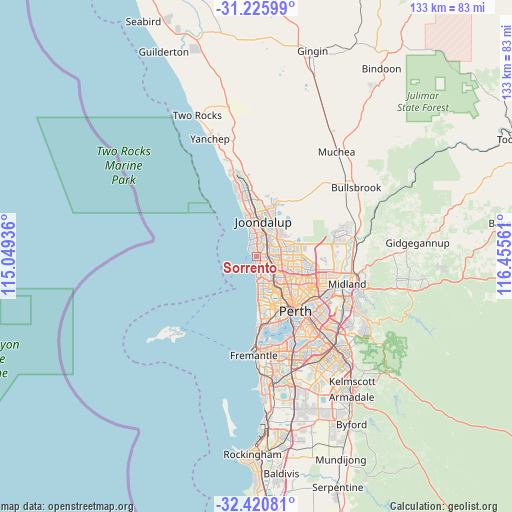
Sorrento GPS coordinates[2]
31° 49' 31.188" South, 115° 45' 8.928" East
| Map corner | latitude | longitude |
|---|---|---|
| Upper-left | -31.22599°, | 115.04936° |
| Center: | -31.82533°, | 115.75248° |
| Lower-right: | -32.42081°, | 116.45561° |
| Map W x H: | 132.9×132.9 km | = 82.6×82.6mi |
| max Lat: | -10.58257° ⇑32% North |
| Sorrento: | -31.82533° |
| min Lat: | ⇓68% South -43.31423° |
| min Long | Sorrento | max Long |
| 113.53327° | 115.75248° | 153.61246° |
| W 2.5%⇐ | ⇒97.5% E |
Elevation
Elevation of Sorrento is 28 m = 92 ft, and this is 94 m = 308 ft below average elevation for this country.
| Max E: |
1715 m = 5627 ft | 63.7% |
| Avg. | 122 m = 400 ft | |
| Sorrento | 28 m = 92 ft | |
Min E: |
-2 m = -7 ft | 36.3% |
See also: Australia elevation on elevation.city.
Geographical zone
Sorrento is located in South temperate zone (between Tropic of Capricorn and the Antarctic Circle). Distance of this Southern Tropic circle is 932.7 km =579.6 mi to North.| Distance of | km | miles | from Sorrento |
|---|---|---|---|
| Equator | 3538.6 | 2198.8 | to North |
| Tropic Capricorn | 932.7 | 579.6 | to North |
| Antarctic Circle | 3862.5 | 2400 | to South |
| South Pole | 6468.4 | 4019.3 | to South |


Nearby cities:
15 places around Sorrento: (largest is in red/bold)
• Beldon
5.7 km =3.5 mi,  9°
9°
• Carine
4.1 km =2.5 mi,  136°
136°
• Craigie
4.5 km =2.8 mi,  21°
21°
• Duncraig
2.4 km =1.5 mi,  110°
110°
• Greenwood
4.7 km =2.9 mi,  92°
92°
• Hillarys
2.3 km =1.4 mi,  330°
330°
• Kallaroo
3.8 km =2.4 mi,  0°
0°
• Kingsley
4.9 km =3 mi,  69°
69°
• Marmion
1.9 km =1.2 mi,  166°
166°
• Mullaloo
5.4 km =3.4 mi,  343°
343°
• North Beach
4.2 km =2.6 mi,  175°
175°
• Padbury
2.6 km =1.6 mi,  36°
36°
• Trigg
4.9 km =3 mi, 174°
• Warwick
5.5 km =3.4 mi, 106°
• Watermans Bay
2.7 km =1.7 mi, 173°
Sources, notices
• [Note1] Compared only with cities in Australia existing in our database
• [Src1] Map data: © OpenStreetMap contributors (CC-BY-SA)
• [Src2] Other city data from geonames.org with taken over terms of usage.
• [Src3] Geographical zone / Annual Mean Temperature by Robert A. Rohde @ Wikipedia
