Padbury geodata
Padbury (Western Australia) is a section of populated place; located in Australia in Australia/Perth (GMT+8) time zone. With population of 7,937 people, there are 839 cities with bigger population in this country. Compared to other cities in Australia, 68.2% of cities are located further ↓South; 96.9% of cities are located further →East and 50.4% of cities have higher elevation than Padbury. Note1


Padbury GPS coordinates[2]
31° 48' 23.22" South, 115° 46' 7.68" East
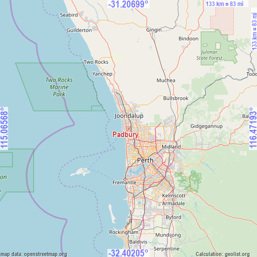
| Map corner | latitude | longitude |
|---|---|---|
| Upper-left | -31.20699°, | 115.06568° |
| Center: | -31.80645°, | 115.7688° |
| Lower-right: | -32.40205°, | 116.47193° |
| Map W x H: | 132.9×132.9 km | = 82.6×82.6mi |
| max Lat: | -10.58257° ⇑31.8% North |
| Padbury: | -31.80645° |
| min Lat: | ⇓68.2% South -43.31423° |
| min Long | Padbury | max Long |
| 113.53327° | 115.7688° | 153.61246° |
| W 3.1%⇐ | ⇒96.9% E |
Elevation
Elevation of Padbury is 45 m = 148 ft, and this is 77 m = 253 ft below average elevation for this country.
| Max E: |
1715 m = 5627 ft | 50.4% |
| Avg. | 122 m = 400 ft | |
| Padbury | 45 m = 148 ft | |
Min E: |
-2 m = -7 ft | 49.6% |
See also: Australia elevation on elevation.city.
Geographical zone
Padbury is located in South temperate zone (between Tropic of Capricorn and the Antarctic Circle). Distance of this Southern Tropic circle is 930.6 km =578.2 mi to North.| Distance of | km | miles | from Padbury |
|---|---|---|---|
| Equator | 3536.5 | 2197.5 | to North |
| Tropic Capricorn | 930.6 | 578.2 | to North |
| Antarctic Circle | 3864.6 | 2401.4 | to South |
| South Pole | 6470.5 | 4020.6 | to South |


Nearby cities:
15 places around Padbury: (largest is in red/bold)
• Beldon
3.6 km =2.2 mi,  350°
350°
• Craigie
2.1 km =1.3 mi,  2°
2°
• Duncraig
3 km =1.9 mi,  167°
167°
• Edgewater
4.7 km =2.9 mi,  15°
15°
• Greenwood
3.9 km =2.4 mi,  125°
125°
• Heathridge
5 km =3.1 mi, 349°
• Hillarys
2.7 km =1.7 mi,  268°
268°
• Kallaroo
2.3 km =1.4 mi,  319°
319°
• Kingsley
3.1 km =1.9 mi,  98°
98°
• Marmion
4.1 km =2.5 mi,  196°
196°
• Mullaloo
4.3 km =2.7 mi, 315°
• Sorrento
2.6 km =1.6 mi,  216°
216°
• Warwick
5.3 km =3.3 mi, 134°
• Watermans Bay
4.9 km =3 mi,  194°
194°
• Woodvale
3.3 km =2.1 mi,  54°
54°
Sources, notices
• [Note1] Compared only with cities in Australia existing in our database
• [Src1] Map data: © OpenStreetMap contributors (CC-BY-SA)
• [Src2] Other city data from geonames.org with taken over terms of usage.
• [Src3] Geographical zone / Annual Mean Temperature by Robert A. Rohde @ Wikipedia
