Kallaroo geodata
Kallaroo (Western Australia) is a section of populated place; located in Australia in Australia/Perth (GMT+8) time zone. With population of 5,042 people, there are 1465 cities with bigger population in this country. Compared to other cities in Australia, 68.2% of cities are located further ↓South; 97.5% of cities are located further →East and 52.4% of cities have higher elevation than Kallaroo. Note1


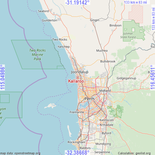
Kallaroo GPS coordinates[2]
31° 47' 27.528" South, 115° 45' 10.728" East
| Map corner | latitude | longitude |
|---|---|---|
| Upper-left | -31.19142°, | 115.04986° |
| Center: | -31.79098°, | 115.75298° |
| Lower-right: | -32.38668°, | 116.45611° |
| Map W x H: | 132.9×132.9 km | = 82.6×82.6mi |
| max Lat: | -10.58257° ⇑31.8% North |
| Kallaroo: | -31.79098° |
| min Lat: | ⇓68.2% South -43.31423° |
| min Long | Kallaroo | max Long |
| 113.53327° | 115.75298° | 153.61246° |
| W 2.5%⇐ | ⇒97.5% E |
Elevation
Elevation of Kallaroo is 42 m = 138 ft, and this is 80 m = 262 ft below average elevation for this country.
| Max E: |
1715 m = 5627 ft | 52.4% |
| Avg. | 122 m = 400 ft | |
| Kallaroo | 42 m = 138 ft | |
Min E: |
-2 m = -7 ft | 47.6% |
See also: Australia elevation on elevation.city.
Geographical zone
Kallaroo is located in South temperate zone (between Tropic of Capricorn and the Antarctic Circle). Distance of this Southern Tropic circle is 928.9 km =577.2 mi to North.| Distance of | km | miles | from Kallaroo |
|---|---|---|---|
| Equator | 3534.8 | 2196.4 | to North |
| Tropic Capricorn | 928.9 | 577.2 | to North |
| Antarctic Circle | 3866.3 | 2402.4 | to South |
| South Pole | 6472.2 | 4021.6 | to South |


Nearby cities:
15 places around Kallaroo: (largest is in red/bold)
• Beldon
2 km =1.2 mi,  26°
26°
• Connolly
4.7 km =2.9 mi,  357°
357°
• Craigie
1.7 km =1.1 mi,  75°
75°
• Duncraig
5.1 km =3.2 mi,  155°
155°
• Edgewater
4 km =2.5 mi,  44°
44°
• Heathridge
3.2 km =2 mi,  10°
10°
• Hillarys
2.1 km =1.3 mi,  213°
213°
• Joondalup
5.4 km =3.4 mi,  15°
15°
• Kingsley
5 km =3.1 mi,  115°
115°
• Marmion
5.6 km =3.5 mi,  176°
176°
• Mullaloo
2 km =1.2 mi,  311°
311°
• Ocean Reef
3.9 km =2.4 mi,  335°
335°
• Padbury
2.3 km =1.4 mi,  139°
139°
• Sorrento
3.8 km =2.4 mi, 180°
• Woodvale
4.1 km =2.5 mi,  87°
87°
Sources, notices
• [Note1] Compared only with cities in Australia existing in our database
• [Src1] Map data: © OpenStreetMap contributors (CC-BY-SA)
• [Src2] Other city data from geonames.org with taken over terms of usage.
• [Src3] Geographical zone / Annual Mean Temperature by Robert A. Rohde @ Wikipedia
