Bees Creek geodata
Bees Creek (Northern Territory) is a section of populated place; located in Australia in Australia/Darwin (GMT+9.5) time zone. With population of 864 people, there are 4030 cities with bigger population in this country. Compared to other cities in Australia, 98.6% of cities are located further ↓South; 87.3% of cities are located further →East and 60% of cities have higher elevation than Bees Creek. Note1


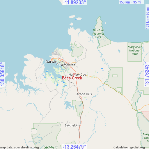
Bees Creek GPS coordinates[2]
12° 34' 46.128" South, 131° 3' 33.48" East
| Map corner | latitude | longitude |
|---|---|---|
| Upper-left | -11.89233°, | 130.35618° |
| Center: | -12.57948°, | 131.0593° |
| Lower-right: | -13.26479°, | 131.76243° |
| Map W x H: | 152.6×152.6 km | = 94.8×94.8mi |
| max Lat: | -10.58257° ⇑1.4% North |
| Bees Creek: | -12.57948° |
| min Lat: | ⇓98.6% South -43.31423° |
| min Long | Bees Creek | max Long |
| 113.53327° | 131.0593° | 153.61246° |
| W 12.7%⇐ | ⇒87.3% E |
Elevation
Elevation of Bees Creek is 32 m = 105 ft, and this is 90 m = 295 ft below average elevation for this country.
| Max E: |
1715 m = 5627 ft | 60% |
| Avg. | 122 m = 400 ft | |
| Bees Creek | 32 m = 105 ft | |
Min E: |
-2 m = -7 ft | 40% |
See also: Australia elevation on elevation.city.
Geographical zone
Bees Creek is located in South Torrid zone (between Equator and Tropic of Capricorn). Distance of this Southern Tropic circle is 1207.2 km =750.1 mi to South.| Distance of | km | miles | from Bees Creek |
|---|---|---|---|
| Equator | 1398.7 | 869.1 | to North |
| Tropic Capricorn | 1207.2 | 750.1 | to South |
| Antarctic Circle | 6002.5 | 3729.8 | to South |
| South Pole | 8608.4 | 5349 | to South |


Nearby cities:
15 places around Bees Creek: (largest is in red/bold)
• Bakewell
11.6 km =7.2 mi,  322°
322°
• Bellamack
10.8 km =6.7 mi,  310°
310°
• Coolalinga
6.6 km =4.1 mi,  342°
342°
• Girraween
7.2 km =4.5 mi,  33°
33°
• Gunn
12.5 km =7.8 mi, 324°
• Herbert
12.2 km =7.6 mi,  65°
65°
• Howard Springs
9.4 km =5.8 mi,  350°
350°
• Humpty Doo
8.4 km =5.2 mi,  93°
93°
• Johnston
11.4 km =7.1 mi,  333°
333°
• McMinns Lagoon
4 km =2.5 mi, 27°
• Moulden
12.4 km =7.7 mi, 311°
• Rosebery
10.9 km =6.8 mi, 314°
• Virginia
7.5 km =4.7 mi, 333°
• Woodroffe
12.2 km =7.6 mi, 315°
• Zuccoli
9.8 km =6.1 mi, 324°
Sources, notices
• [Note1] Compared only with cities in Australia existing in our database
• [Src1] Map data: © OpenStreetMap contributors (CC-BY-SA)
• [Src2] Other city data from geonames.org with taken over terms of usage.
• [Src3] Geographical zone / Annual Mean Temperature by Robert A. Rohde @ Wikipedia
