Kaleen geodata
Kaleen (ACT) is a section of populated place; located in Australia in Australia/Sydney (GMT+11) time zone. With population of 7,092 people, there are 967 cities with bigger population in this country. Compared to other cities in Australia, 74.6% of cities are located further ↑North; 54% of cities are located further ←West and 95.8% of cities have lower elevation than Kaleen. Note1


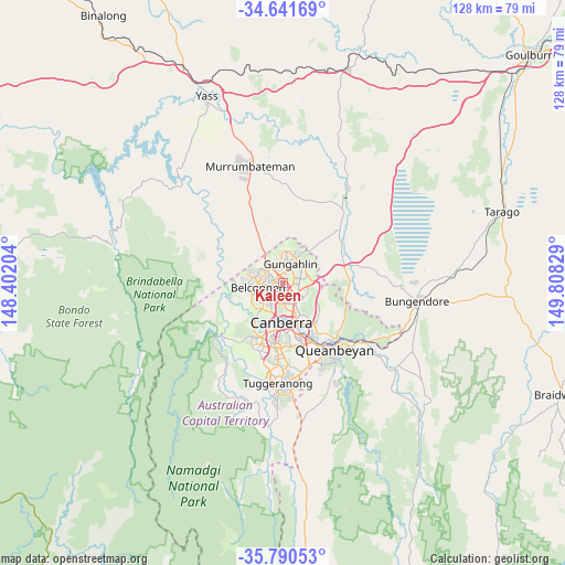
Kaleen GPS coordinates[2]
35° 13' 5.304" South, 149° 6' 18.576" East
| Map corner | latitude | longitude |
|---|---|---|
| Upper-left | -34.64169°, | 148.40204° |
| Center: | -35.21814°, | 149.10516° |
| Lower-right: | -35.79053°, | 149.80829° |
| Map W x H: | 127.7×127.7 km | = 79.3×79.3mi |
| max Lat: | -10.58257° ⇑74.6% North |
| Kaleen: | -35.21814° |
| min Lat: | ⇓25.4% South -43.31423° |
| min Long | Kaleen | max Long |
| 113.53327° | 149.10516° | 153.61246° |
| W 54%⇐ | ⇒46% E |
Elevation
Elevation of Kaleen is 599 m = 1965 ft, and this is 477 m = 1565 ft above average elevation for this country.
| Max E: |
1715 m = 5627 ft | 4.2% |
| Kaleen | 599 m 1965 ft | |
| Avg. | 122 m = 400 ft | |
Min E: |
-2 m = -7 ft | 95.8% |
See also: Australia elevation on elevation.city.
Geographical zone
Kaleen is located in South temperate zone (between Tropic of Capricorn and the Antarctic Circle). Distance of this Southern Tropic circle is 1310 km =814 mi to North.| Distance of | km | miles | from Kaleen |
|---|---|---|---|
| Equator | 3915.9 | 2433.2 | to North |
| Tropic Capricorn | 1310 | 814 | to North |
| Antarctic Circle | 3485.3 | 2165.7 | to South |
| South Pole | 6091.2 | 3784.9 | to South |


Nearby cities:
15 places around Kaleen: (largest is in red/bold)
• Belconnen
4.2 km =2.6 mi,  238°
238°
• Bruce
3.2 km =2 mi,  204°
204°
• Crace
1.7 km =1.1 mi,  6°
6°
• Downer
4.6 km =2.9 mi,  129°
129°
• Evatt
3.4 km =2.1 mi,  281°
281°
• Franklin
4 km =2.5 mi,  59°
59°
• Giralang
1.2 km =0.7 mi,  313°
313°
• Gungahlin
4.5 km =2.8 mi,  38°
38°
• Lyneham
3.3 km =2.1 mi,  136°
136°
• McKellar
2.6 km =1.6 mi,  271°
271°
• Melba
4.7 km =2.9 mi, 280°
• Nicholls
3.5 km =2.2 mi,  347°
347°
• O'Connor
4.3 km =2.7 mi,  171°
171°
• Palmerston
2.9 km =1.8 mi,  26°
26°
• Spence
4.3 km =2.7 mi,  300°
300°
Sources, notices
• [Note1] Compared only with cities in Australia existing in our database
• [Src1] Map data: © OpenStreetMap contributors (CC-BY-SA)
• [Src2] Other city data from geonames.org with taken over terms of usage.
• [Src3] Geographical zone / Annual Mean Temperature by Robert A. Rohde @ Wikipedia
