Giralang geodata
Giralang (ACT) is a section of populated place; located in Australia in Australia/Sydney (GMT+11) time zone. With population of 3,242 people, there are 2098 cities with bigger population in this country. Compared to other cities in Australia, 74.5% of cities are located further ↑North; 53.8% of cities are located further ←West and 96% of cities have lower elevation than Giralang. Note1


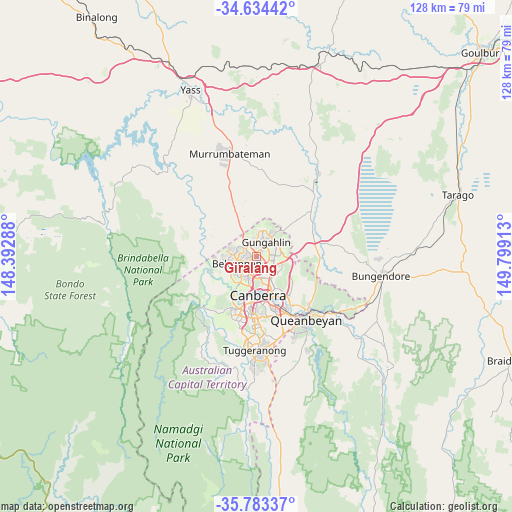
Giralang GPS coordinates[2]
35° 12' 39.348" South, 149° 5' 45.6" East
| Map corner | latitude | longitude |
|---|---|---|
| Upper-left | -34.63442°, | 148.39288° |
| Center: | -35.21093°, | 149.096° |
| Lower-right: | -35.78337°, | 149.79913° |
| Map W x H: | 127.8×127.8 km | = 79.4×79.4mi |
| max Lat: | -10.58257° ⇑74.5% North |
| Giralang: | -35.21093° |
| min Lat: | ⇓25.5% South -43.31423° |
| min Long | Giralang | max Long |
| 113.53327° | 149.096° | 153.61246° |
| W 53.8%⇐ | ⇒46.2% E |
Elevation
Elevation of Giralang is 604 m = 1982 ft, and this is 482 m = 1581 ft above average elevation for this country.
| Max E: |
1715 m = 5627 ft | 4% |
| Giralang | 604 m 1982 ft | |
| Avg. | 122 m = 400 ft | |
Min E: |
-2 m = -7 ft | 96% |
See also: Australia elevation on elevation.city.
Geographical zone
Giralang is located in South temperate zone (between Tropic of Capricorn and the Antarctic Circle). Distance of this Southern Tropic circle is 1309.2 km =813.5 mi to North.| Distance of | km | miles | from Giralang |
|---|---|---|---|
| Equator | 3915.1 | 2432.7 | to North |
| Tropic Capricorn | 1309.2 | 813.5 | to North |
| Antarctic Circle | 3486.1 | 2166.2 | to South |
| South Pole | 6092 | 3785.4 | to South |


Nearby cities:
15 places around Giralang: (largest is in red/bold)
• Belconnen
4 km =2.5 mi,  221°
221°
• Bruce
3.7 km =2.3 mi,  187°
187°
• Crace
1.4 km =0.9 mi,  48°
48°
• Evatt
2.5 km =1.6 mi,  267°
267°
• Florey
4.5 km =2.8 mi,  248°
248°
• Franklin
4.5 km =2.8 mi,  73°
73°
• Gungahlin
4.5 km =2.8 mi, 53°
• Kaleen
1.2 km =0.7 mi,  133°
133°
• Lyneham
4.5 km =2.8 mi,  135°
135°
• McKellar
1.9 km =1.2 mi, 246°
• Melba
3.8 km =2.4 mi, 271°
• Ngunnawal
4.5 km =2.8 mi,  18°
18°
• Nicholls
2.6 km =1.6 mi,  0°
0°
• Palmerston
2.8 km =1.7 mi, 49°
• Spence
3.2 km =2 mi,  295°
295°
Sources, notices
• [Note1] Compared only with cities in Australia existing in our database
• [Src1] Map data: © OpenStreetMap contributors (CC-BY-SA)
• [Src2] Other city data from geonames.org with taken over terms of usage.
• [Src3] Geographical zone / Annual Mean Temperature by Robert A. Rohde @ Wikipedia
