Hughes geodata
Hughes (ACT) is a section of populated place; located in Australia in Australia/Sydney (GMT+11) time zone. With population of 2,900 people, there are 2317 cities with bigger population in this country. Compared to other cities in Australia, 75.7% of cities are located further ↑North; 53.8% of cities are located further ←West and 95.6% of cities have lower elevation than Hughes. Note1


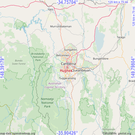
Hughes GPS coordinates[2]
35° 19' 57.684" South, 149° 5' 41.676" East
| Map corner | latitude | longitude |
|---|---|---|
| Upper-left | -34.75704°, | 148.39179° |
| Center: | -35.33269°, | 149.09491° |
| Lower-right: | -35.90426°, | 149.79804° |
| Map W x H: | 127.6×127.6 km | = 79.3×79.3mi |
| max Lat: | -10.58257° ⇑75.7% North |
| Hughes: | -35.33269° |
| min Lat: | ⇓24.3% South -43.31423° |
| min Long | Hughes | max Long |
| 113.53327° | 149.09491° | 153.61246° |
| W 53.8%⇐ | ⇒46.2% E |
Elevation
Elevation of Hughes is 596 m = 1955 ft, and this is 474 m = 1555 ft above average elevation for this country.
| Max E: |
1715 m = 5627 ft | 4.4% |
| Hughes | 596 m 1955 ft | |
| Avg. | 122 m = 400 ft | |
Min E: |
-2 m = -7 ft | 95.6% |
See also: Australia elevation on elevation.city.
Geographical zone
Hughes is located in South temperate zone (between Tropic of Capricorn and the Antarctic Circle). Distance of this Southern Tropic circle is 1322.7 km =821.9 mi to North.| Distance of | km | miles | from Hughes |
|---|---|---|---|
| Equator | 3928.6 | 2441.1 | to North |
| Tropic Capricorn | 1322.7 | 821.9 | to North |
| Antarctic Circle | 3472.5 | 2157.7 | to South |
| South Pole | 6078.4 | 3776.9 | to South |


Nearby cities:
15 places around Hughes: (largest is in red/bold)
• Chifley
2.8 km =1.7 mi,  215°
215°
• Curtin
1.8 km =1.1 mi,  299°
299°
• Deakin
1.7 km =1.1 mi,  26°
26°
• Forrest
3.6 km =2.2 mi,  57°
57°
• Garran
1.6 km =1 mi,  130°
130°
• Griffith
3.9 km =2.4 mi,  77°
77°
• Lyons
2.1 km =1.3 mi,  245°
245°
• Mawson
3.4 km =2.1 mi,  174°
174°
• O'Malley
2.7 km =1.7 mi,  143°
143°
• Pearce
3.4 km =2.1 mi,  197°
197°
• Phillip
2 km =1.2 mi,  188°
188°
• Red Hill
2.3 km =1.4 mi,  71°
71°
• Waramanga
3.7 km =2.3 mi,  232°
232°
• Weston
3.2 km =2 mi,  263°
263°
• Yarralumla
3.8 km =2.4 mi,  15°
15°
Sources, notices
• [Note1] Compared only with cities in Australia existing in our database
• [Src1] Map data: © OpenStreetMap contributors (CC-BY-SA)
• [Src2] Other city data from geonames.org with taken over terms of usage.
• [Src3] Geographical zone / Annual Mean Temperature by Robert A. Rohde @ Wikipedia
