Mawson geodata
Mawson (ACT) is a section of populated place; located in Australia in Australia/Sydney (GMT+11) time zone. With population of 3,163 people, there are 2154 cities with bigger population in this country. Compared to other cities in Australia, 76.3% of cities are located further ↑North; 53.9% of cities are located further ←West and 97.3% of cities have lower elevation than Mawson. Note1


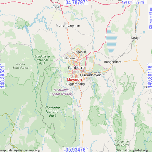
Mawson GPS coordinates[2]
35° 21' 48.24" South, 149° 5' 55.068" East
| Map corner | latitude | longitude |
|---|---|---|
| Upper-left | -34.78797°, | 148.39551° |
| Center: | -35.3634°, | 149.09863° |
| Lower-right: | -35.93476°, | 149.80176° |
| Map W x H: | 127.5×127.5 km | = 79.2×79.2mi |
| max Lat: | -10.58257° ⇑76.3% North |
| Mawson: | -35.3634° |
| min Lat: | ⇓23.7% South -43.31423° |
| min Long | Mawson | max Long |
| 113.53327° | 149.09863° | 153.61246° |
| W 53.9%⇐ | ⇒46.1% E |
Elevation
Elevation of Mawson is 640 m = 2100 ft, and this is 518 m = 1699 ft above average elevation for this country.
| Max E: |
1715 m = 5627 ft | 2.7% |
| Mawson | 640 m 2100 ft | |
| Avg. | 122 m = 400 ft | |
Min E: |
-2 m = -7 ft | 97.3% |
See also: Australia elevation on elevation.city.
Geographical zone
Mawson is located in South temperate zone (between Tropic of Capricorn and the Antarctic Circle). Distance of this Southern Tropic circle is 1326.1 km =824 mi to North.| Distance of | km | miles | from Mawson |
|---|---|---|---|
| Equator | 3932 | 2443.2 | to North |
| Tropic Capricorn | 1326.1 | 824 | to North |
| Antarctic Circle | 3469.1 | 2155.6 | to South |
| South Pole | 6075 | 3774.8 | to South |


Nearby cities:
15 places around Mawson: (largest is in red/bold)
• Chifley
2.3 km =1.4 mi,  299°
299°
• Farrer
1.6 km =1 mi,  158°
158°
• Fisher
3.8 km =2.4 mi,  273°
273°
• Garran
2.5 km =1.6 mi,  20°
20°
• Hughes
3.4 km =2.1 mi,  354°
354°
• Isaacs
1.6 km =1 mi,  110°
110°
• Kambah
4.5 km =2.8 mi,  235°
235°
• Lyons
3.4 km =2.1 mi,  318°
318°
• O'Malley
1.8 km =1.1 mi,  46°
46°
• Pearce
1.4 km =0.9 mi,  275°
275°
• Phillip
1.6 km =1 mi,  336°
336°
• Red Hill
4.5 km =2.8 mi, 24°
• Torrens
1.4 km =0.9 mi,  225°
225°
• Wanniassa
3.9 km =2.4 mi,  190°
190°
• Waramanga
3.5 km =2.2 mi,  289°
289°
Sources, notices
• [Note1] Compared only with cities in Australia existing in our database
• [Src1] Map data: © OpenStreetMap contributors (CC-BY-SA)
• [Src2] Other city data from geonames.org with taken over terms of usage.
• [Src3] Geographical zone / Annual Mean Temperature by Robert A. Rohde @ Wikipedia
