Melba geodata
Melba (ACT) is a section of populated place; located in Australia in Australia/Sydney (GMT+11) time zone. With population of 3,063 people, there are 2220 cities with bigger population in this country. Compared to other cities in Australia, 74.5% of cities are located further ↑North; 53.1% of cities are located further ←West and 95.5% of cities have lower elevation than Melba. Note1


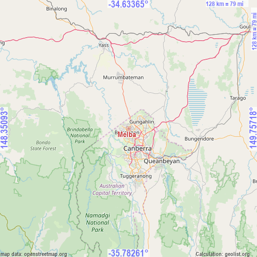
Melba GPS coordinates[2]
35° 12' 36.576" South, 149° 3' 14.58" East
| Map corner | latitude | longitude |
|---|---|---|
| Upper-left | -34.63365°, | 148.35093° |
| Center: | -35.21016°, | 149.05405° |
| Lower-right: | -35.78261°, | 149.75718° |
| Map W x H: | 127.8×127.8 km | = 79.4×79.4mi |
| max Lat: | -10.58257° ⇑74.5% North |
| Melba: | -35.21016° |
| min Lat: | ⇓25.5% South -43.31423° |
| min Long | Melba | max Long |
| 113.53327° | 149.05405° | 153.61246° |
| W 53.1%⇐ | ⇒46.9% E |
Elevation
Elevation of Melba is 594 m = 1949 ft, and this is 472 m = 1549 ft above average elevation for this country.
| Max E: |
1715 m = 5627 ft | 4.5% |
| Melba | 594 m 1949 ft | |
| Avg. | 122 m = 400 ft | |
Min E: |
-2 m = -7 ft | 95.5% |
See also: Australia elevation on elevation.city.
Geographical zone
Melba is located in South temperate zone (between Tropic of Capricorn and the Antarctic Circle). Distance of this Southern Tropic circle is 1309.1 km =813.4 mi to North.| Distance of | km | miles | from Melba |
|---|---|---|---|
| Equator | 3915 | 2432.7 | to North |
| Tropic Capricorn | 1309.1 | 813.4 | to North |
| Antarctic Circle | 3486.2 | 2166.2 | to South |
| South Pole | 6092.1 | 3785.5 | to South |


Nearby cities:
15 places around Melba: (largest is in red/bold)
• Belconnen
3.3 km =2.1 mi,  160°
160°
• Charnwood
2.1 km =1.3 mi,  301°
301°
• Dunlop
3.6 km =2.2 mi, 300°
• Evatt
1.4 km =0.9 mi,  98°
98°
• Florey
1.8 km =1.1 mi,  191°
191°
• Flynn
1 km =0.6 mi, 297°
• Fraser
2.2 km =1.4 mi,  338°
338°
• Giralang
3.8 km =2.4 mi,  91°
91°
• Higgins
3.5 km =2.2 mi,  224°
224°
• Latham
2.2 km =1.4 mi,  251°
251°
• Macgregor
3.9 km =2.4 mi,  270°
270°
• McKellar
2.2 km =1.4 mi,  111°
111°
• Page
3.2 km =2 mi, 186°
• Scullin
3 km =1.9 mi,  206°
206°
• Spence
1.6 km =1 mi,  36°
36°
Sources, notices
• [Note1] Compared only with cities in Australia existing in our database
• [Src1] Map data: © OpenStreetMap contributors (CC-BY-SA)
• [Src2] Other city data from geonames.org with taken over terms of usage.
• [Src3] Geographical zone / Annual Mean Temperature by Robert A. Rohde @ Wikipedia
