Bucca geodata
Bucca (New South Wales) is a section of populated place; located in Australia in Australia/Sydney (GMT+11) time zone. With population of 533 people, there are 4770 cities with bigger population in this country. Compared to other cities in Australia, 72.1% of cities are located further ↓South; 94.6% of cities are located further ←West and 67.8% of cities have lower elevation than Bucca. Note1


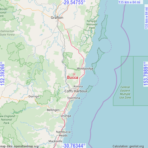
Bucca GPS coordinates[2]
30° 9' 26.532" South, 153° 5' 44.808" East
| Map corner | latitude | longitude |
|---|---|---|
| Upper-left | -29.54755°, | 152.39266° |
| Center: | -30.15737°, | 153.09578° |
| Lower-right: | -30.76344°, | 153.79891° |
| Map W x H: | 135.2×135.2 km | = 84×84mi |
| max Lat: | -10.58257° ⇑27.9% North |
| Bucca: | -30.15737° |
| min Lat: | ⇓72.1% South -43.31423° |
| min Long | Bucca | max Long |
| 113.53327° | 153.09578° | 153.61246° |
| W 94.6%⇐ | ⇒5.4% E |
Elevation
Elevation of Bucca is 92 m = 302 ft, and this is 30 m = 98 ft below average elevation for this country.
| Max E: |
1715 m = 5627 ft | 32.2% |
| Avg. | 122 m = 400 ft | |
| Bucca | 92 m = 302 ft | |
Min E: |
-2 m = -7 ft | 67.8% |
See also: Australia elevation on elevation.city.
Geographical zone
Bucca is located in South temperate zone (between Tropic of Capricorn and the Antarctic Circle). Distance of this Southern Tropic circle is 747.3 km =464.4 mi to North.| Distance of | km | miles | from Bucca |
|---|---|---|---|
| Equator | 3353.2 | 2083.6 | to North |
| Tropic Capricorn | 747.3 | 464.4 | to North |
| Antarctic Circle | 4048 | 2515.3 | to South |
| South Pole | 6653.9 | 4134.5 | to South |


Nearby cities:
15 places around Bucca: (largest is in red/bold)
• Arrawarra
14.1 km =8.8 mi,  40°
40°
• Arrawarra Headland
13.8 km =8.6 mi,  45°
45°
• Coffs Harbour
15.5 km =9.6 mi,  173°
173°
• Coramba
10.6 km =6.6 mi,  228°
228°
• Emerald Beach
8.3 km =5.2 mi,  94°
94°
• Glenreagh
16.1 km =10 mi,  315°
315°
• Karangi
12.9 km =8 mi,  199°
199°
• Korora
10 km =6.2 mi, 169°
• Moonee Beach
7.7 km =4.8 mi,  134°
134°
• Mullaway
12.9 km =8 mi, 48°
• Nana Glen
8.1 km =5 mi,  289°
289°
• Sandy Beach
9.4 km =5.8 mi,  82°
82°
• Sapphire Beach
8.6 km =5.3 mi,  153°
153°
• Upper Orara
16.8 km =10.4 mi,  213°
213°
• Woolgoolga
11.3 km =7 mi,  62°
62°
Sources, notices
• [Note1] Compared only with cities in Australia existing in our database
• [Src1] Map data: © OpenStreetMap contributors (CC-BY-SA)
• [Src2] Other city data from geonames.org with taken over terms of usage.
• [Src3] Geographical zone / Annual Mean Temperature by Robert A. Rohde @ Wikipedia
