Mullaway geodata
Mullaway (New South Wales) is a section of populated place; located in Australia in Australia/Sydney (GMT+11) time zone. With population of 560 people, there are 4680 cities with bigger population in this country. Compared to other cities in Australia, 72.2% of cities are located further ↓South; 96.6% of cities are located further ←West and 62.8% of cities have higher elevation than Mullaway. Note1


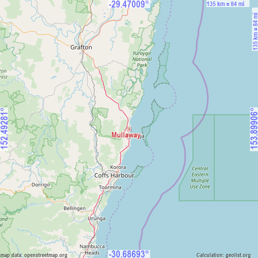
Mullaway GPS coordinates[2]
30° 4' 49.368" South, 153° 11' 45.348" East
| Map corner | latitude | longitude |
|---|---|---|
| Upper-left | -29.47009°, | 152.49281° |
| Center: | -30.08038°, | 153.19593° |
| Lower-right: | -30.68693°, | 153.89906° |
| Map W x H: | 135.3×135.3 km | = 84.1×84.1mi |
| max Lat: | -10.58257° ⇑27.8% North |
| Mullaway: | -30.08038° |
| min Lat: | ⇓72.2% South -43.31423° |
| min Long | Mullaway | max Long |
| 113.53327° | 153.19593° | 153.61246° |
| W 96.6%⇐ | ⇒3.4% E |
Elevation
Elevation of Mullaway is 29 m = 95 ft, and this is 93 m = 305 ft below average elevation for this country.
| Max E: |
1715 m = 5627 ft | 62.8% |
| Avg. | 122 m = 400 ft | |
| Mullaway | 29 m = 95 ft | |
Min E: |
-2 m = -7 ft | 37.2% |
See also: Australia elevation on elevation.city.
Geographical zone
Mullaway is located in South temperate zone (between Tropic of Capricorn and the Antarctic Circle). Distance of this Southern Tropic circle is 738.7 km =459 mi to North.| Distance of | km | miles | from Mullaway |
|---|---|---|---|
| Equator | 3344.6 | 2078.2 | to North |
| Tropic Capricorn | 738.7 | 459 | to North |
| Antarctic Circle | 4056.5 | 2520.6 | to South |
| South Pole | 6662.4 | 4139.8 | to South |


Nearby cities:
15 places around Mullaway: (largest is in red/bold)
• Arrawarra
2.3 km =1.4 mi,  347°
347°
• Arrawarra Headland
1.1 km =0.7 mi,  7°
7°
• Bucca
12.9 km =8 mi,  228°
228°
• Coramba
23.5 km =14.6 mi, 228°
• Corindi
6.1 km =3.8 mi,  0°
0°
• Corindi Beach
7.2 km =4.5 mi, 351°
• Emerald Beach
9.4 km =5.8 mi,  188°
188°
• Glenreagh
21.1 km =13.1 mi,  278°
278°
• Korora
20 km =12.4 mi,  202°
202°
• Moonee Beach
14.5 km =9 mi, 196°
• Nana Glen
18.2 km =11.3 mi,  251°
251°
• Red Rock
11 km =6.8 mi,  15°
15°
• Sandy Beach
7.4 km =4.6 mi,  182°
182°
• Sapphire Beach
17.2 km =10.7 mi, 199°
• Woolgoolga
3.4 km =2.1 mi,  172°
172°
Sources, notices
• [Note1] Compared only with cities in Australia existing in our database
• [Src1] Map data: © OpenStreetMap contributors (CC-BY-SA)
• [Src2] Other city data from geonames.org with taken over terms of usage.
• [Src3] Geographical zone / Annual Mean Temperature by Robert A. Rohde @ Wikipedia
