Arrawarra Headland geodata
Arrawarra Headland (New South Wales) is a populated place; located in Australia in Australia/Sydney (GMT+11) time zone. With population of 575 people, there are 4631 cities with bigger population in this country. Compared to other cities in Australia, 72.2% of cities are located further ↓South; 96.6% of cities are located further ←West and 80.4% of cities have higher elevation than Arrawarra Headland. Note1


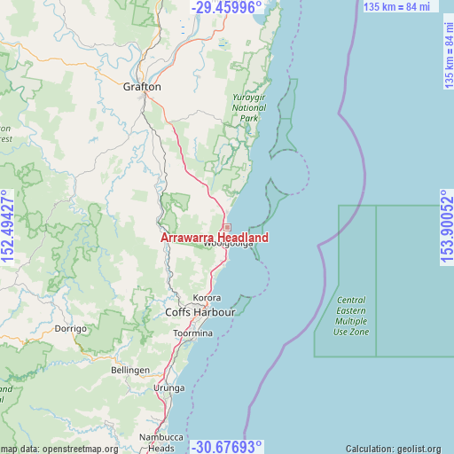
Arrawarra Headland GPS coordinates[2]
30° 4' 13.152" South, 153° 11' 50.604" East
| Map corner | latitude | longitude |
|---|---|---|
| Upper-left | -29.45996°, | 152.49427° |
| Center: | -30.07032°, | 153.19739° |
| Lower-right: | -30.67693°, | 153.90052° |
| Map W x H: | 135.3×135.3 km | = 84.1×84.1mi |
| max Lat: | -10.58257° ⇑27.8% North |
| Arrawarra Headland: | -30.07032° |
| min Lat: | ⇓72.2% South -43.31423° |
| min Long | Arrawarra Headl | max Long |
| 113.53327° | 153.19739° | 153.61246° |
| W 96.6%⇐ | ⇒3.4% E |
Elevation
Elevation of Arrawarra Headland is 15 m = 49 ft, and this is 107 m = 351 ft below average elevation for this country.
| Max E: |
1715 m = 5627 ft | 80.4% |
| Avg. | 122 m = 400 ft | |
| Arrawarra Headland | 15 m = 49 ft | |
Min E: |
-2 m = -7 ft | 19.6% |
See also: Australia elevation on elevation.city.
Geographical zone
Arrawarra Headland is located in South temperate zone (between Tropic of Capricorn and the Antarctic Circle). Distance of this Southern Tropic circle is 737.6 km =458.3 mi to North.| Distance of | km | miles | from Arrawarra Headland |
|---|---|---|---|
| Equator | 3343.5 | 2077.6 | to North |
| Tropic Capricorn | 737.6 | 458.3 | to North |
| Antarctic Circle | 4057.7 | 2521.3 | to South |
| South Pole | 6663.6 | 4140.6 | to South |


Nearby cities:
15 places around Arrawarra Headland: (largest is in red/bold)
• Arrawarra
1.3 km =0.8 mi,  329°
329°
• Bucca
13.8 km =8.6 mi,  225°
225°
• Coramba
24.3 km =15.1 mi, 226°
• Corindi
5 km =3.1 mi,  358°
358°
• Corindi Beach
6.1 km =3.8 mi,  349°
349°
• Emerald Beach
10.5 km =6.5 mi,  188°
188°
• Glenreagh
21.1 km =13.1 mi,  275°
275°
• Korora
21.1 km =13.1 mi,  202°
202°
• Moonee Beach
15.7 km =9.8 mi, 195°
• Mullaway
1.1 km =0.7 mi, 187°
• Nana Glen
18.7 km =11.6 mi,  248°
248°
• Red Rock
9.9 km =6.2 mi,  16°
16°
• Sandy Beach
8.5 km =5.3 mi,  183°
183°
• Sapphire Beach
18.3 km =11.4 mi, 198°
• Woolgoolga
4.5 km =2.8 mi, 175°
Sources, notices
• [Note1] Compared only with cities in Australia existing in our database
• [Src1] Map data: © OpenStreetMap contributors (CC-BY-SA)
• [Src2] Other city data from geonames.org with taken over terms of usage.
• [Src3] Geographical zone / Annual Mean Temperature by Robert A. Rohde @ Wikipedia
