Woolgoolga geodata
Woolgoolga (New South Wales) is a populated place; located in Australia in Australia/Sydney (GMT+11) time zone. With population of 5,495 people, there are 1345 cities with bigger population in this country. Compared to other cities in Australia, 72.2% of cities are located further ↓South; 96.7% of cities are located further ←West and 93.8% of cities have higher elevation than Woolgoolga. Note1


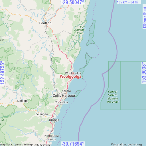
Woolgoolga GPS coordinates[2]
30° 6' 38.088" South, 153° 12' 2.412" East
| Map corner | latitude | longitude |
|---|---|---|
| Upper-left | -29.50047°, | 152.49755° |
| Center: | -30.11058°, | 153.20067° |
| Lower-right: | -30.71694°, | 153.9038° |
| Map W x H: | 135.3×135.3 km | = 84.1×84.1mi |
| max Lat: | -10.58257° ⇑27.8% North |
| Woolgoolga: | -30.11058° |
| min Lat: | ⇓72.2% South -43.31423° |
| min Long | Woolgoolga | max Long |
| 113.53327° | 153.20067° | 153.61246° |
| W 96.7%⇐ | ⇒3.3% E |
Elevation
Elevation of Woolgoolga is 7 m = 23 ft, and this is 115 m = 377 ft below average elevation for this country.
| Max E: |
1715 m = 5627 ft | 93.8% |
| Avg. | 122 m = 400 ft | |
| Woolgoolga | 7 m = 23 ft | |
Min E: |
-2 m = -7 ft | 6.2% |
See also: Australia elevation on elevation.city.
Geographical zone
Woolgoolga is located in South temperate zone (between Tropic of Capricorn and the Antarctic Circle). Distance of this Southern Tropic circle is 742.1 km =461.1 mi to North.| Distance of | km | miles | from Woolgoolga |
|---|---|---|---|
| Equator | 3348 | 2080.4 | to North |
| Tropic Capricorn | 742.1 | 461.1 | to North |
| Antarctic Circle | 4053.2 | 2518.5 | to South |
| South Pole | 6659.1 | 4137.8 | to South |


Nearby cities:
15 places around Woolgoolga: (largest is in red/bold)
• Arrawarra
5.6 km =3.5 mi,  350°
350°
• Arrawarra Headland
4.5 km =2.8 mi,  355°
355°
• Bucca
11.3 km =7 mi,  242°
242°
• Coffs Harbour
22.3 km =13.9 mi,  202°
202°
• Coramba
21.7 km =13.5 mi, 235°
• Corindi
9.4 km =5.8 mi, 357°
• Corindi Beach
10.5 km =6.5 mi, 352°
• Emerald Beach
6.2 km =3.9 mi, 196°
• Korora
17.2 km =10.7 mi,  208°
208°
• Moonee Beach
11.5 km =7.1 mi, 203°
• Mullaway
3.4 km =2.1 mi, 352°
• Nana Glen
17.9 km =11.1 mi,  261°
261°
• Red Rock
14.2 km =8.8 mi,  9°
9°
• Sandy Beach
4.1 km =2.5 mi,  191°
191°
• Sapphire Beach
14.3 km =8.9 mi, 205°
Sources, notices
• [Note1] Compared only with cities in Australia existing in our database
• [Src1] Map data: © OpenStreetMap contributors (CC-BY-SA)
• [Src2] Other city data from geonames.org with taken over terms of usage.
• [Src3] Geographical zone / Annual Mean Temperature by Robert A. Rohde @ Wikipedia
