Huntingdale geodata
Huntingdale (Western Australia) is a section of populated place; located in Australia in Australia/Perth (GMT+8) time zone. With population of 8,525 people, there are 758 cities with bigger population in this country. Compared to other cities in Australia, 63.7% of cities are located further ↓South; 93% of cities are located further →East and 72.3% of cities have higher elevation than Huntingdale. Note1


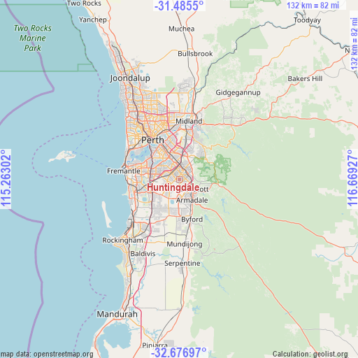
Huntingdale GPS coordinates[2]
32° 4' 59.448" South, 115° 57' 58.104" East
| Map corner | latitude | longitude |
|---|---|---|
| Upper-left | -31.4855°, | 115.26302° |
| Center: | -32.08318°, | 115.96614° |
| Lower-right: | -32.67697°, | 116.66927° |
| Map W x H: | 132.5×132.5 km | = 82.3×82.3mi |
| max Lat: | -10.58257° ⇑36.3% North |
| Huntingdale: | -32.08318° |
| min Lat: | ⇓63.7% South -43.31423° |
| min Long | Huntingdale | max Long |
| 113.53327° | 115.96614° | 153.61246° |
| W 7%⇐ | ⇒93% E |
Elevation
Elevation of Huntingdale is 21 m = 69 ft, and this is 101 m = 331 ft below average elevation for this country.
| Max E: |
1715 m = 5627 ft | 72.3% |
| Avg. | 122 m = 400 ft | |
| Huntingdale | 21 m = 69 ft | |
Min E: |
-2 m = -7 ft | 27.7% |
See also: Australia elevation on elevation.city.
Geographical zone
Huntingdale is located in South temperate zone (between Tropic of Capricorn and the Antarctic Circle). Distance of this Southern Tropic circle is 961.4 km =597.4 mi to North.| Distance of | km | miles | from Huntingdale |
|---|---|---|---|
| Equator | 3567.3 | 2216.6 | to North |
| Tropic Capricorn | 961.4 | 597.4 | to North |
| Antarctic Circle | 3833.9 | 2382.3 | to South |
| South Pole | 6439.7 | 4001.4 | to South |


Nearby cities:
15 places around Huntingdale: (largest is in red/bold)
• Beckenham
6.5 km =4 mi,  354°
354°
• Camillo
4.7 km =2.9 mi,  134°
134°
• Canning Vale
5.3 km =3.3 mi,  301°
301°
• Champion Lakes
4.4 km =2.7 mi,  154°
154°
• Ferndale
6.8 km =4.2 mi,  322°
322°
• Gosnells
3.7 km =2.3 mi,  86°
86°
• Harrisdale
4.2 km =2.6 mi,  223°
223°
• Kenwick
5.5 km =3.4 mi,  0°
0°
• Langford
5.2 km =3.2 mi,  333°
333°
• Lynwood
5.9 km =3.7 mi, 323°
• Maddington
4 km =2.5 mi,  23°
23°
• Parkwood
5.9 km =3.7 mi,  310°
310°
• Seville Grove
6.3 km =3.9 mi,  159°
159°
• Southern River
2.7 km =1.7 mi,  194°
194°
• Thornlie
2.8 km =1.7 mi,  337°
337°
Sources, notices
• [Note1] Compared only with cities in Australia existing in our database
• [Src1] Map data: © OpenStreetMap contributors (CC-BY-SA)
• [Src2] Other city data from geonames.org with taken over terms of usage.
• [Src3] Geographical zone / Annual Mean Temperature by Robert A. Rohde @ Wikipedia
