Torrington geodata
Torrington (Queensland) is a section of populated place; located in Australia in Australia/Brisbane (GMT+10) time zone. With population of 879 people, there are 4004 cities with bigger population in this country. Compared to other cities in Australia, 81.1% of cities are located further ↓South; 81.7% of cities are located further ←West and 94.2% of cities have lower elevation than Torrington. Note1


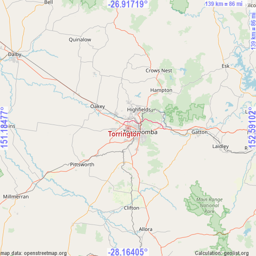
Torrington GPS coordinates[2]
27° 32' 32.604" South, 151° 53' 16.404" East
| Map corner | latitude | longitude |
|---|---|---|
| Upper-left | -26.91719°, | 151.18477° |
| Center: | -27.54239°, | 151.88789° |
| Lower-right: | -28.16405°, | 152.59102° |
| Map W x H: | 138.6×138.6 km | = 86.1×86.1mi |
| max Lat: | -10.58257° ⇑18.9% North |
| Torrington: | -27.54239° |
| min Lat: | ⇓81.1% South -43.31423° |
| min Long | Torrington | max Long |
| 113.53327° | 151.88789° | 153.61246° |
| W 81.7%⇐ | ⇒18.3% E |
Elevation
Elevation of Torrington is 557 m = 1827 ft, and this is 435 m = 1427 ft above average elevation for this country.
| Max E: |
1715 m = 5627 ft | 5.8% |
| Torrington | 557 m 1827 ft | |
| Avg. | 122 m = 400 ft | |
Min E: |
-2 m = -7 ft | 94.2% |
See also: Australia elevation on elevation.city.
Geographical zone
Torrington is located in South temperate zone (between Tropic of Capricorn and the Antarctic Circle). Distance of this Southern Tropic circle is 456.5 km =283.7 mi to North.| Distance of | km | miles | from Torrington |
|---|---|---|---|
| Equator | 3062.4 | 1902.9 | to North |
| Tropic Capricorn | 456.5 | 283.7 | to North |
| Antarctic Circle | 4338.7 | 2695.9 | to South |
| South Pole | 6944.6 | 4315.2 | to South |


Nearby cities:
15 places around Torrington: (largest is in red/bold)
• Cotswold Hills
2.3 km =1.4 mi,  17°
17°
• Cranley
4.6 km =2.9 mi,  48°
48°
• Darling Heights
7.3 km =4.5 mi,  145°
145°
• Drayton
6.5 km =4 mi,  168°
168°
• Glenvale
2.9 km =1.8 mi, 169°
• Gowrie Junction
6.6 km =4.1 mi,  356°
356°
• Harlaxton
7.8 km =4.8 mi,  82°
82°
• Harristown
6.4 km =4 mi,  135°
135°
• Newtown
4.7 km =2.9 mi,  108°
108°
• North Toowoomba
7.2 km =4.5 mi,  91°
91°
• Rockville
5 km =3.1 mi, 81°
• South Toowoomba
6.6 km =4.1 mi,  118°
118°
• Toowoomba
6.8 km =4.2 mi, 107°
• Wilsonton
2.9 km =1.8 mi, 91°
• Wilsonton Heights
3.8 km =2.4 mi,  72°
72°
Sources, notices
• [Note1] Compared only with cities in Australia existing in our database
• [Src1] Map data: © OpenStreetMap contributors (CC-BY-SA)
• [Src2] Other city data from geonames.org with taken over terms of usage.
• [Src3] Geographical zone / Annual Mean Temperature by Robert A. Rohde @ Wikipedia
