Maidstone geodata
Maidstone (Victoria) is a section of populated place; located in Australia in Australia/Melbourne (GMT+11) time zone. With population of 8,956 people, there are 706 cities with bigger population in this country. Compared to other cities in Australia, 86.8% of cities are located further ↑North; 68.3% of cities are located further →East and 55.2% of cities have higher elevation than Maidstone. Note1


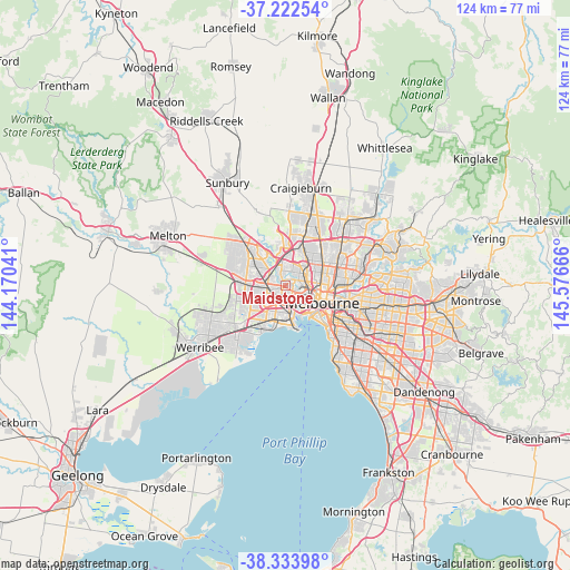
Maidstone GPS coordinates[2]
37° 46' 49.26" South, 144° 52' 24.708" East
| Map corner | latitude | longitude |
|---|---|---|
| Upper-left | -37.22254°, | 144.17041° |
| Center: | -37.78035°, | 144.87353° |
| Lower-right: | -38.33398°, | 145.57666° |
| Map W x H: | 123.6×123.6 km | = 76.8×76.8mi |
| max Lat: | -10.58257° ⇑86.8% North |
| Maidstone: | -37.78035° |
| min Lat: | ⇓13.2% South -43.31423° |
| min Long | Maidstone | max Long |
| 113.53327° | 144.87353° | 153.61246° |
| W 31.7%⇐ | ⇒68.3% E |
Elevation
Elevation of Maidstone is 38 m = 125 ft, and this is 84 m = 276 ft below average elevation for this country.
| Max E: |
1715 m = 5627 ft | 55.2% |
| Avg. | 122 m = 400 ft | |
| Maidstone | 38 m = 125 ft | |
Min E: |
-2 m = -7 ft | 44.8% |
See also: Australia elevation on elevation.city.
Geographical zone
Maidstone is located in South temperate zone (between Tropic of Capricorn and the Antarctic Circle). Distance of this Southern Tropic circle is 1594.9 km =991 mi to North.| Distance of | km | miles | from Maidstone |
|---|---|---|---|
| Equator | 4200.8 | 2610.3 | to North |
| Tropic Capricorn | 1594.9 | 991 | to North |
| Antarctic Circle | 3200.4 | 1988.6 | to South |
| South Pole | 5806.3 | 3607.9 | to South |


Nearby cities:
15 places around Maidstone: (largest is in red/bold)
• Aberfeldie
3.1 km =1.9 mi,  42°
42°
• Ascot Vale
4.3 km =2.7 mi,  89°
89°
• Avondale Heights
2.3 km =1.4 mi,  335°
335°
• Braybrook
1.8 km =1.1 mi,  246°
246°
• Essendon
4.7 km =2.9 mi, 44°
• Essendon West
3 km =1.9 mi,  17°
17°
• Footscray
3.2 km =2 mi,  133°
133°
• Kingsville
3.1 km =1.9 mi,  171°
171°
• Maribyrnong
1.3 km =0.8 mi,  47°
47°
• Moonee Ponds
4.1 km =2.5 mi,  68°
68°
• Seddon
3.2 km =2 mi,  152°
152°
• Sunshine
3.5 km =2.2 mi,  264°
264°
• Sunshine North
4.2 km =2.6 mi,  286°
286°
• West Footscray
1.9 km =1.2 mi, 170°
• Yarraville
4.7 km =2.9 mi, 150°
Sources, notices
• [Note1] Compared only with cities in Australia existing in our database
• [Src1] Map data: © OpenStreetMap contributors (CC-BY-SA)
• [Src2] Other city data from geonames.org with taken over terms of usage.
• [Src3] Geographical zone / Annual Mean Temperature by Robert A. Rohde @ Wikipedia
