Crawley geodata
Crawley (Western Australia) is a section of populated place; located in Australia in Australia/Perth (GMT+8) time zone. With population of 4,202 people, there are 1715 cities with bigger population in this country. Compared to other cities in Australia, 65.3% of cities are located further ↓South; 95.7% of cities are located further →East and 88.3% of cities have higher elevation than Crawley. Note1


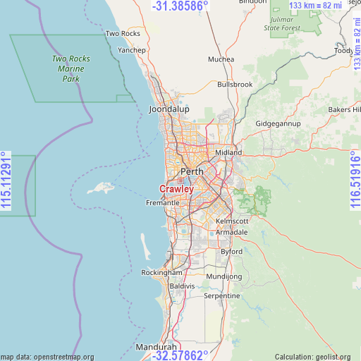
Crawley GPS coordinates[2]
31° 59' 3.048" South, 115° 48' 57.708" East
| Map corner | latitude | longitude |
|---|---|---|
| Upper-left | -31.38586°, | 115.11291° |
| Center: | -31.98418°, | 115.81603° |
| Lower-right: | -32.57862°, | 116.51916° |
| Map W x H: | 132.6×132.6 km | = 82.4×82.4mi |
| max Lat: | -10.58257° ⇑34.7% North |
| Crawley: | -31.98418° |
| min Lat: | ⇓65.3% South -43.31423° |
| min Long | Crawley | max Long |
| 113.53327° | 115.81603° | 153.61246° |
| W 4.3%⇐ | ⇒95.7% E |
Elevation
Elevation of Crawley is 10 m = 33 ft, and this is 112 m = 367 ft below average elevation for this country.
| Max E: |
1715 m = 5627 ft | 88.3% |
| Avg. | 122 m = 400 ft | |
| Crawley | 10 m = 33 ft | |
Min E: |
-2 m = -7 ft | 11.7% |
See also: Australia elevation on elevation.city.
Geographical zone
Crawley is located in South temperate zone (between Tropic of Capricorn and the Antarctic Circle). Distance of this Southern Tropic circle is 950.4 km =590.6 mi to North.| Distance of | km | miles | from Crawley |
|---|---|---|---|
| Equator | 3556.3 | 2209.8 | to North |
| Tropic Capricorn | 950.4 | 590.6 | to North |
| Antarctic Circle | 3844.9 | 2389.1 | to South |
| South Pole | 6450.8 | 4008.3 | to South |


Nearby cities:
15 places around Crawley: (largest is in red/bold)
• Applecross
4 km =2.5 mi,  155°
155°
• Attadale
4.7 km =2.9 mi,  196°
196°
• Claremont
3.2 km =2 mi,  279°
279°
• Como
4.5 km =2.8 mi,  99°
99°
• Daglish
3.7 km =2.3 mi,  349°
349°
• Dalkeith
2 km =1.2 mi,  231°
231°
• Jolimont
4.3 km =2.7 mi, 351°
• Mount Claremont
4 km =2.5 mi,  308°
308°
• Nedlands
0.9 km =0.6 mi,  287°
287°
• Peppermint Grove
4.8 km =3 mi,  250°
250°
• Perth city centre
4.8 km =3 mi,  43°
43°
• Shenton Park
3.6 km =2.2 mi,  331°
331°
• South Perth
4.8 km =3 mi,  88°
88°
• Subiaco
4.1 km =2.5 mi,  14°
14°
• West Perth
4.6 km =2.9 mi,  32°
32°
Sources, notices
• [Note1] Compared only with cities in Australia existing in our database
• [Src1] Map data: © OpenStreetMap contributors (CC-BY-SA)
• [Src2] Other city data from geonames.org with taken over terms of usage.
• [Src3] Geographical zone / Annual Mean Temperature by Robert A. Rohde @ Wikipedia
