Dudley geodata
Dudley (New South Wales) is a section of populated place; located in Australia in Australia/Sydney (GMT+11) time zone. With population of 2,300 people, there are 2694 cities with bigger population in this country. Compared to other cities in Australia, 57.5% of cities are located further ↓South; 80.7% of cities are located further ←West and 62.4% of cities have lower elevation than Dudley. Note1


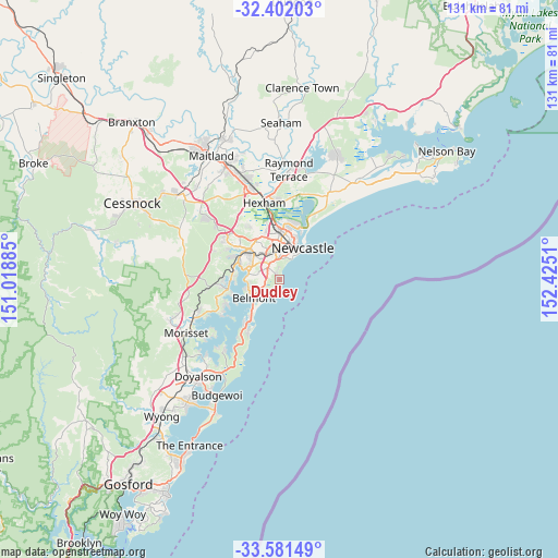
Dudley GPS coordinates[2]
32° 59' 37.428" South, 151° 43' 19.092" East
| Map corner | latitude | longitude |
|---|---|---|
| Upper-left | -32.40203°, | 151.01885° |
| Center: | -32.99373°, | 151.72197° |
| Lower-right: | -33.58149°, | 152.4251° |
| Map W x H: | 131.1×131.1 km | = 81.5×81.5mi |
| max Lat: | -10.58257° ⇑42.5% North |
| Dudley: | -32.99373° |
| min Lat: | ⇓57.5% South -43.31423° |
| min Long | Dudley | max Long |
| 113.53327° | 151.72197° | 153.61246° |
| W 80.7%⇐ | ⇒19.3% E |
Elevation
Elevation of Dudley is 71 m = 233 ft, and this is 51 m = 167 ft below average elevation for this country.
| Max E: |
1715 m = 5627 ft | 37.6% |
| Avg. | 122 m = 400 ft | |
| Dudley | 71 m = 233 ft | |
Min E: |
-2 m = -7 ft | 62.4% |
See also: Australia elevation on elevation.city.
Geographical zone
Dudley is located in South temperate zone (between Tropic of Capricorn and the Antarctic Circle). Distance of this Southern Tropic circle is 1062.6 km =660.3 mi to North.| Distance of | km | miles | from Dudley |
|---|---|---|---|
| Equator | 3668.6 | 2279.6 | to North |
| Tropic Capricorn | 1062.6 | 660.3 | to North |
| Antarctic Circle | 3732.6 | 2319.3 | to South |
| South Pole | 6338.5 | 3938.6 | to South |


Nearby cities:
15 places around Dudley: (largest is in red/bold)
• Adamstown Heights
5.1 km =3.2 mi,  347°
347°
• Charlestown
3.9 km =2.4 mi,  316°
316°
• Gateshead
3.1 km =1.9 mi,  294°
294°
• Highfields
4.6 km =2.9 mi, 348°
• Hillsborough
5.6 km =3.5 mi,  304°
304°
• Jewells
4.3 km =2.7 mi,  238°
238°
• Kahibah
3.7 km =2.3 mi, 346°
• Kotara South
5.4 km =3.4 mi,  327°
327°
• Merewether
5.5 km =3.4 mi,  21°
21°
• Merewether Heights
5.3 km =3.3 mi,  13°
13°
• Mount Hutton
5 km =3.1 mi,  283°
283°
• Redhead
2.2 km =1.4 mi,  206°
206°
• Tingira Heights
4.8 km =3 mi,  265°
265°
• Whitebridge
2.2 km =1.4 mi, 345°
• Windale
3.8 km =2.4 mi, 271°
Sources, notices
• [Note1] Compared only with cities in Australia existing in our database
• [Src1] Map data: © OpenStreetMap contributors (CC-BY-SA)
• [Src2] Other city data from geonames.org with taken over terms of usage.
• [Src3] Geographical zone / Annual Mean Temperature by Robert A. Rohde @ Wikipedia
