Qunaba geodata
Qunaba (Queensland) is a populated place; located in Australia in Australia/Brisbane (GMT+10) time zone. With population of 774 people, there are 4196 cities with bigger population in this country. Compared to other cities in Australia, 90.3% of cities are located further ↓South; 84.1% of cities are located further ←West and 58.4% of cities have higher elevation than Qunaba. Note1


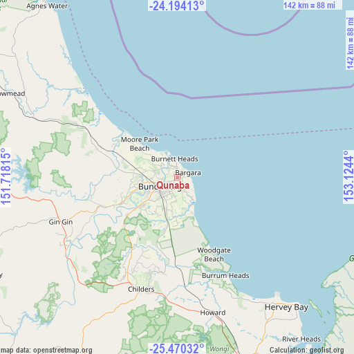
Qunaba GPS coordinates[2]
24° 50' 1.932" South, 152° 25' 16.572" East
| Map corner | latitude | longitude |
|---|---|---|
| Upper-left | -24.19413°, | 151.71815° |
| Center: | -24.83387°, | 152.42127° |
| Lower-right: | -25.47032°, | 153.1244° |
| Map W x H: | 141.9×141.9 km | = 88.2×88.2mi |
| max Lat: | -10.58257° ⇑9.7% North |
| Qunaba: | -24.83387° |
| min Lat: | ⇓90.3% South -43.31423° |
| min Long | Qunaba | max Long |
| 113.53327° | 152.42127° | 153.61246° |
| W 84.1%⇐ | ⇒15.9% E |
Elevation
Elevation of Qunaba is 34 m = 112 ft, and this is 88 m = 289 ft below average elevation for this country.
| Max E: |
1715 m = 5627 ft | 58.4% |
| Avg. | 122 m = 400 ft | |
| Qunaba | 34 m = 112 ft | |
Min E: |
-2 m = -7 ft | 41.6% |
See also: Australia elevation on elevation.city.
Geographical zone
Qunaba is located in South temperate zone (between Tropic of Capricorn and the Antarctic Circle). Distance of this Southern Tropic circle is 155.3 km =96.5 mi to North.| Distance of | km | miles | from Qunaba |
|---|---|---|---|
| Equator | 2761.3 | 1715.8 | to North |
| Tropic Capricorn | 155.3 | 96.5 | to North |
| Antarctic Circle | 4639.9 | 2883.1 | to South |
| South Pole | 7245.8 | 4502.3 | to South |


Nearby cities:
15 places around Qunaba: (largest is in red/bold)
• Ashfield
5 km =3.1 mi,  211°
211°
• Avenell Heights
8.2 km =5.1 mi,  221°
221°
• Bargara
4.7 km =2.9 mi,  62°
62°
• Bundaberg
8.2 km =5.1 mi,  244°
244°
• Bundaberg East
5 km =3.1 mi, 236°
• Bundaberg North
7.7 km =4.8 mi,  257°
257°
• Bundaberg South
7.6 km =4.7 mi, 235°
• Burnett Heads
7.7 km =4.8 mi,  353°
353°
• Coral Cove
8.3 km =5.2 mi,  131°
131°
• Gooburrum
9.1 km =5.7 mi,  277°
277°
• Innes Park
7 km =4.3 mi,  122°
122°
• Kalkie
3.8 km =2.4 mi,  252°
252°
• Kepnock
6.6 km =4.1 mi, 224°
• Walkervale
8.3 km =5.2 mi,  229°
229°
• Woongarra
7.2 km =4.5 mi,  179°
179°
Sources, notices
• [Note1] Compared only with cities in Australia existing in our database
• [Src1] Map data: © OpenStreetMap contributors (CC-BY-SA)
• [Src2] Other city data from geonames.org with taken over terms of usage.
• [Src3] Geographical zone / Annual Mean Temperature by Robert A. Rohde @ Wikipedia
